Purpose
This document is intended to provide both a description of, and justification for, each of the Primary Constituent Elements (PCE) that was used in developing the proposed Critical Habitat (CH) rule for the Lost River and shortnose suckers. The existence of PCE's within any part of the Upper Klamath basin watershed would not mean that such a place was automatically included in the proposed CH, nor would the absence of PCE's in a given area mean that the area could not fall within the boundary of a critical habitat unit.
This document will also be useful for determining what types of actions may be considered as having the potential to affect any of the PCE's. This role will be important in conferences on the proposed rule. Comments on this document may be sent to:
Authors
The primary authors of this document are Rollie White and Paul Henson, Ph.D., U.S. Fish and Wildlife Service, Oregon State Office, Portland, Oregon, and Kevin Stubby, U.S. Fish and Wildlife Service, Sacramento Field Office, Sacramento, California.
Acknowledgements
We wish to acknowledge some of those who have helped in the preparation of
this document. Our greatest thanks goes to the many researchers who have spent
years collecting valuable data on the fishes in the Upper Klamath River Basin.
Without these data, there would be no hope for the recovery of these species.
Thanks to Gail Kobetich and Teresa Nichols for guidance and support, and to
Henry Maddux for his vision of how this project could be done. Thanks also to
Wayne Elmore for providing focus to the riparian discussion sections of this
document. Thanks to Linda Wester for her perseverance in the mapping effort,
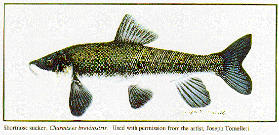
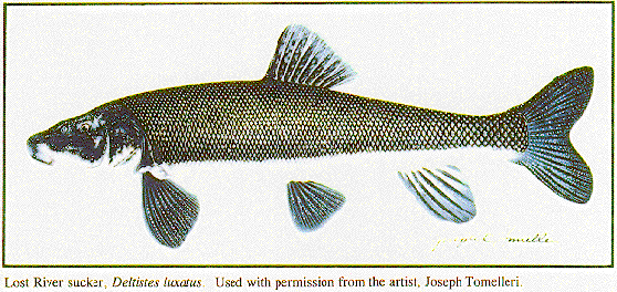
and to Joe Tomelleri for the use of his illustrations. The efforts of these,
and many other people, have made this report possible.
(1) Space for individual and population growth, and for normal behavior:
(2) Food, water, air, light, minerals, or other nutritional or physiological requirements:
(3) Cover or shelter:
(4) Sites for breeding, reproduction, rearing of offspring, germination, or seed dispersal; and generally,
(5) Habitats that are protected from disturbance or are representative of the historical geographical and ecological distributions of a species.
In addition, the Endangered Species Act of 1973, as amended (Act), recognizes that areas containing these elements may require special management considerations or protection. The need to provide such management does not disqualify an area from designation.
The primary constituent elements (PCE's) determined necessary to the survival and recovery of the Lost River and shortnose sucker include:
Water -- This PCE includes a quantity of water of sufficient quality (i.e., temperature, dissolved oxygen, pH, lack of nutrients, contaminants, turbidity, etc.) that is delivered to a specific location in accordance with a hydrologic regime that is required for the particular life stage for each species. This also includes those physical and structural features of a functioning watershed (i.e., springs, riparian areas, wetlands, floodplains, etc.) that provide or maintain water quality sufficient to meet the current or future needs of the suckers.
Physical Habitat - This PCE includes areas of the Upper Klamath Basin watershed that are inhabited or potentially habitable by suckers for use as refugia from stressful water quality conditions or predation, or in spawning, nursery, feeding, rearing, normal behavior, or as corridors between these areas. These areas include seasonal wetlands and areas used or potentially used seasonally by the listed suckers.
Biological Environment - Food supply, predation, parasitism, and competition are important elements of the biological environment and are considered components of this constituent element. Food supply is a function of nutrient supply, productivity, and availability for each life stage of the species. Predation, although considered a normal component of this environment, may be out of balance due to introduced fish species or the elimination of refugial structures. Competition from nonnative fish species and parasitism may also be elevated due to stresses induced by degraded habitats.
These primary constituent elements form complex interrelationships in the life history of the Lost River and shortnose suckers. These relationships are a prime consideration in the selection of proposed critical habitat areas.
Upper Klamath Lake is hypertrophic due, in part, to excessive and accelerated energy and nutrient inflow (Kane and Smith 1993, Barica 1980). Inflowing nutrients to the lake are a major factor in the development of large blooms of the algae Aphanizomenon flos-aquae. After these algae blooms complete their natural cycling (typically two cycles in a summer season), there is a population crash when available nutrients or weather conditions become insufficient to support the vast algae biomass. High levels of photosynthesis associated with algae growth results in pH levels as high as 10.5 (Kane and Smith 1993). Falter and Cech (1991) found that high pH levels in these ranges will cause loss of equilibrium of shortnose suckers under laboratory conditions, and Kann and Smith (1993) concluded that pH may be an important factor limiting fish success in Upper Klamath Lake.
Recent lake conditions indicate that the quality of inflowing waters probably influences these algae cycles. Kann and Smith (1993) reported in the summer of 1992 that there was only one major algal peak. This was a year of very low flows, low to absent peak flows, and warm air and water temperatures very early in the year. There was an algal crash, but there was no return to higher densities and a second peak as is typical. Water quality conditions remained relatively good throughout the summer, and there were no reported sucker mortalities in Upper Klamath Lake. A potential reason for the differences in 1992 is that the low flows and absence of a peak run-off flow reduced the amount of available nutrients in the water column in the lake, thus preventing the typical algal cycling. Maloney et al. (1972) described the relationship of nutrients to the eutrophication process, and it appears that phosphorus is a particularly important nutrient driving this process.
Miller and Tash (1967) stated "the quantity of nitrogen and phosphorous in only the upper inch of lake sediments is as great as that quantity which would flow into the lake during the next 60 years if the present rate of inflow continues." However, the availability of sediment nutrients is unknown. The algal dynamics of 1992 suggest that the mere presence of these nutrients is not sufficient to make them ecologically available to the algae, in turn affecting water quality for suckers. The amount and timing of inflowing nutrients, perhaps through surface and groundwater, appear to be a driving force behind algal dynamics.
In summary, there is substantial evidence that excess nutrients, elevated
pH levels, low dissolved oxygen levels, high water temperatures, and other
water quality conditions associated with hypertrophy are detrimental to
fish living in Upper Klamath Lake (Kane and Smith 1993, Monda and Saiki
1993, Monda and Saiki 1994). In 1986, for example, large numbers of suckers
and other fish died after a particularly bad crash in the algae populations.
No single water quality parameter can be isolated as the primary cause
of the decline in the sucker populations. Instead, the synergistic effects
of various parameters are suspected to induce stress in the suckers and
contribute to the decline in sucker productivity and recruitment. Restoration
of the lake habitat and its ecological processes will only be accomplished
with the protection and improvement of the terrestrial and riparian environments
surrounding the lakes and their tributaries (Moyle and Sato 1991, USFWS
1993).
Unfortunately, many of these areas have been lost or are seriously degraded due to channelization (Simpson et al. 1982), draining, filling, logging (Coats and Miller 1981), grazing (Armour et al. 1991, Elmore in press,), damming, and irrigation diversions. This loss is a major cause of the water quality problems discussed above. Eliminating these problems, and restoring the sucker populations in the Klamath Basin, will depend on our ability to recreate or restore many of these wetland and riparian areas. In general, wetlands are highly variable and complex systems that serve important functions to fish communities (Moyle and Leidy 1992).
A riparian area is a combination of the aquatic ecosystem and the portions of the adjacent terrestrial ecosystem that can affect or are affected by the aquatic environment. This includes streams, rivers, lakes, lake margins, floodplains, wetlands, and associated upland hillslopes (Gregory and Ashkenas 1990). Riparian areas include not just lands, but the vertical vegetative component that provides habitat and energy resources to stream-associated biota (Gregory et al. 1991). Wetlands described in this document include typical riparian areas as well as seasonal or permanent wetlands that lie within the historic floodplain of the stream or are adjacent to the lake (see Gregory et al. 1991).
The relationship between water quality and healthy riparian areas is well-documented (Karr and Schlosser 1978, Schlosser and Karr 1981, Chesters and Schierow 1985, Elmore in press). Many studies have demonstrated the negative effects of poorly managed livestock grazing, logging activity, agriculture, and road building on riparian habitats (Coats and Miller 1981, Peterjohn and Correll 1984, Duda 1985, Chaney et al. 1990, Meehan 1991, Elmore in press, EPA 1994). The relationship between riparian conditions and these land management practices is in some cases direct and obvious, and in others it is indirect and subtle. Livestock grazing, for example, often leads to riparian areas with little vegetation to protect and shade streambanks, a lowered water table and reduced summer flows, higher water temperatures in summer and cooler temperatures or ice formation in winter, and an overall reduction in habitat quality for aquatic and terrestrial organisms. Restored or undisturbed riparian areas have diverse vegetation and root systems that protect and shade streambanks, elevate water tables, provide better water temperature regimes, and improve habitat conditions for riparian organisms.
Many of the Klamath Basin streams exhibit the degraded riparian conditions described above. Large floodplain storage areas have been lost. These areas allowed streams to deposit many of the nutrients and sediments carried during spring flood flows on to the floodplain (Reichmuth 1986, Schlosser 1991). The Sprague River and Lost River, for example, have been severely modified by channelization, reduction or elimination of riparian vegetation, diversion of water, upstream dams on the Lost River (USFWS 1993), and non-point source pollution (DEQ 1992). Neither river is allowed to meander naturally through its lower floodplain, and there have been large-scale losses of adjacent wetlands as a result of land and water management activities. All of these conditions contribute to water quality problems in the Klamath Basin lakes and rivers.
The provision or maintenance of water quality is sometimes a function of the source of water rather than stream riparian conditions or lakeshore wetlands. The protection of groundwater as source aquifers for springs may be important to water quality in the springs and downstream streams or lakes. Springs around the Upper Klamath Lake and Agency Lake basin are known to provide present or historic sucker spawning habitat. On the west side of Upper Klamath Lake, many of these springs are directly responsible for water quality refugia in the Pelican Bay area (USFWS 1993). Such areas may need to be managed independently of the riparian issues discussed above.
"For a given level of productivity, the transit time of energy in the community and the storage of chemical energy in living biomass are directly related: the longer the transit time, the greater the accumulation of living and dead biomass. Energy storage in the ecosystem has important implications for the stability of the biological community and its ability to withstand perturbation."
This energy storage concept can be applied directly to managing lake water quality because nutrients and energy that are bound up in the ecosystem above the lake (i.e., farther up in the watershed) are not available in the lake to affect the algal/water quality cycle. An example cited by Ricklefs (1979, Table 41-8) shows that average productivity and production of swamp and marshland results in a 6-year nutrient transit time. This compares to a transit time of 15 days for nutrients suspended in the water column in stream ecosystems. The wetland system also transfers a percentage of those nutrients to components that may eventually leave the system (e.g., through herbivores or carnivores). Thus, the main benefit gained from binding nutrients and energy into wetland and riparian ecosystems is the reduced availability of the nutrients that drive the algal cycle in the lake and impair other ecosystem processes.
One could view the restoration of lakeshore marshes as having a similar effect to that of a flood control structure on a river. A wetland stores nutrients and energy, slowing their release into other parts of the system just as a dam stores and releases water. The wetland collects high nutrient spikes and releases those nutrients at a level that can be assimilated by the receiving ecosystem. A healthy system of wetlands is needed on the margins of Upper Klamath Lake to store incoming nutrients that are arriving at elevated levels from the degraded upstream watershed. Such wetlands are especially important near river inflow points.
The Service believes that a greater accumulation of living and dead biomass in the ecosystem upstream of the lake will create a longer transit time of those nutrients into the lake, which in turn will bring about improved water quality. While background primary productivity will always be occurring in the upper watersheds, it is excessive nutrient input to streams from other sources such as erosion, fertilization, road building, logging, grazing, and other land manipulations that make large amounts of nutrients available in the lake (Chaney et al. 1990, Oregon State University 1984, Reeves and Sedell 1992). Many of these activities also occur at smaller scales that have a negative cumulative effect on water quality (Panek 1979, Coats and Miller 1981, Burns 1991). These land management activities can be seen as methods of mining the stored nutrients and energy throughout the watershed so that they are made available to the aquatic ecosystem at an accelerated rate.
Compared to the present degraded conditions, the restoration of marshes and riparian areas in the Klamath Basin will result in a stabilization of nutrient inputs. High peaks of dissolved or transported nutrients that currently enter with high flows would be reduced to relatively stable seasonal releases by the marshes. This change in pattern would also lead to a
release of a large portion of the bound nutrients during the seasons when algae blooms are not of concern, thus greatly improving habitat conditions for suckers and other lake organisms.
Habitats that slow the transit time of energy and nutrients through the watershed will also reduce the net amount of energy and nutrients that reach the lake. Recent research has shown that phosphorus immobilization processes occur within intact riparian ecosystems when compared to disturbed systems (Green and Kaufman 1989), and phosphorus had been shown to greatly increase algal production in lakes (Maloney et al. 1972). The binding of energy and nutrients into soils and plant matter makes those nutrients available to other energetic pathways, trapping the nutrients within the riparian complex or allowing them to exit the system altogether (Lowrance et al. 1984).
For example, nutrients and contaminants that settle into sediments may be broken down by bacteria and other life-forms and incorporated into large soil banks that provide the structure upon which riparian vegetation develops. At the other extreme, some nutrients and energy trapped in soils become incorporated into riparian plants and aquatic organisms that are taken up by foraging animals. These animals incorporate the energy into either tissues or pass the nutrients as droppings within or outside the riparian zone. The capacity of riparian areas to store energy and nutrients is also exploited commercially by managers that use wetlands to treat waste water or to grow crops.
This need to manage riparian and watershed resources to maintain ecological functions is well documented by researchers, as are the benefits of restoration (Baltz and Moyle 1984, Knight and Bottorf 1984, Elmore and Beschta 1987, Chaney et al. 1990, Platts 1991). Healthy watersheds will store water in wetlands, riparian zones, groundwater areas, and behind physical barriers. The amount of water that can be stored for slow release through the year can be large. This natural storage can result in water temperatures that are cooler in the summer and warmer in the winter. The re-establishment of wetlands and riparian areas throughout the Upper Klamath Basin will act to reduce the magnitude of spring floods, bring up summer baseflows, drop stream temperatures, and generally improve water quality flowing downstream. Within streams, this increase of base flows will provide lower stress environments than are currently available to suckers, maintain migration and escape routes until later in the season, and provide protection from predators and enhanced habitat by increasing the average depth of pools.
The riparian ecosystem contains a variety of natural and managed pathways through which excess nutrients and energy are removed from the water and bound into either sediments or plant and animal matter. These pathways, if restored and functioning properly, will decrease the amount of nutrients that enter Upper Klamath Lake and will alleviate water quality problems.
An important component of this constituent element is the availability of areas of refuge from poor water quality conditions. The habitats that provide these areas include those currently identified (see discussion below of Critical Habitat Units), but also any areas discovered at a later time within those critical habitat units that are designated through this proposed listing process. Similarly, the number and extent of water quality refugia may increase as watershed conditions improve.
Areas that provide, or have the potential to provide, habitat for important life history functions such as spawning, nursery, feeding, rearing, and normal behavior (habitats used for no particular life stage other than continued existence) are also components of this constituent element. Of these, feeding areas are probably the least well known at this time and may never be segregated from the other habitat types. Many areas where suckers are currently found may serve unknown life history needs. Some spawning, nursery, and rearing habitats have been studied, and known areas are identified in the Recovery Plan (USFWS 1993).
Corridor areas between other physical habitat types are also a component of this constituent element (Schlosser 1991). Particularly important are areas that provide for spawning migrations or passage from areas of low water quality to water quality refugia (Moyle and Sato 1991). Additionally, larval and juvenile suckers depend on migration corridors to enable travel from spawning and rearing areas to normal behavior habitats. Some corridor areas may only function as such for a short time or under specific hydrologic conditions. These areas would still be considered important components of this constituent element, even if they only held water on an intermittent basis.
Refugia from predation are important components of this constituent element. Although predation has not been well studied, it probably contributes to the failure of some year classes (USFWS 1993, Dunsmoor 1993, see also Baltz and Moyle 1993). Predation by fishes, and possibly bullfrogs, on Klamath suckers is probably limited to predation on larvae or juveniles because adults of either species would be too large to be eaten by other fishes in the basin. Pelicans may be the only significant predators of adults of either species.
Current and Historic Range: Proposed critical habitat units include much of the known current and historic ranges of both species. Some portions of the currently inhabited range are not included in this proposed rule, and no potentially suitable habitats outside either the current or historic range of either species are included.
Suitable Spawning and Migration Habitats: Areas known to provide either spawning habitat or migration corridors to or from spawning habitats are included in this proposed rule.
Areas Likely to Provide Water Quality: Areas within the current or historic range of both species that are likely to provide for water quality are included in this proposed rule. In general, these sites were known refugial areas (such as Pelican Bay), water sources such as springs, or those areas falling within the 100-year floodplain, where defined, or areas within 300 feet on either side of streams within the current or historic range of the species. Many wetland areas are included because of their important role in maintaining water quality.
Areas to Maintain Rangewide Distribution: The major habitats currently utilized by both species across their respective ranges are included within the proposed designation.
Areas to Reduce Fragmentation of Populations: The boundaries of proposed critical habitat units were drawn to reduce the likelihood of separating, for example, a spawning habitat from the population of suckers that uses that habitat.
Adequacy of Existing Protection: The Service considered the legal status of lands in proposing specific areas as critical habitat. Areas with permanent legal protection, such as congressionally-designated wilderness areas, national parks, and portions of national wildlife refuges are not proposed.
Application of the foregoing criteria resulted in the proposal of three main types of aquatic habitats and associated uplands within the Upper Klamath Basin watershed:
1) Lakes, reservoirs, rivers, and streams within the current or historic distribution of the Lost River and/or shortnose sucker;
2) Lands adjacent to habitats identified in 1) (above) lying within the 100-year floodplain as defined on Federal Emergency Management Agency (FEMA) Flood Insurance Rate Maps (FIRM); and,
3) Lands adjacent to stream habitats identified in 1) (above) but outside areas where FEMA 100-year flood plains have been identified in 2) (above), but that fall within a zone extending 300 feet on either side of the stream or river.
Included within the proposed designation are Federal, state and private lands and waters. The six units proposed would provide additional protection for the major habitat and/or population areas, and this protection would further the conservation of the species by maintaining the health and status of all major populations.
The Service has proposed the 100-year FEMA floodplains as an indicator of the likely distribution of the primary constituent elements, and those features that provide for the primary constituent elements, because the 100-year floodplains are a product of the normal long-term function of the stream. In places, the floodplain may be altered from its natural state by human activities, but in most cases these alterations also would affect the ability of those portions of the floodplain to provide the primary constituent elements. In such cases as these, inclusion of the 100-year historic floodplain as an indicator would be inappropriate.
FEMA has not mapped a 100-year floodplain on many portions of the upper watershed. According to a 1993 report by the interagency Forest Ecosystem Management Assessment Team (FEMAT), riparian zones, which provide for a majority of the primary constituent elements and components thereof, consist of "...areas where the vegetation complex and microclimate conditions are products of the combined presence and influence of perennial and/or intermittent water, associated high water tables, and soils that exhibit some wetness characteristics. " The FEMAT report (USDA et al. 1993) contains a comprehensive review of riparian ecosystem components, and specifies that riparian zones for fish bearing streams should consist of " ...the area on either side of the stream extending from the edges of the active stream channel to the top of the inner gorge, or to the outer edges of the 100-year floodplain, or to the outer edges of riparian vegetation, or to a distance equal to the height of two site potential trees, or 300 feet slope distance (600 feet, including both sides of the stream channel), whichever is greatest".
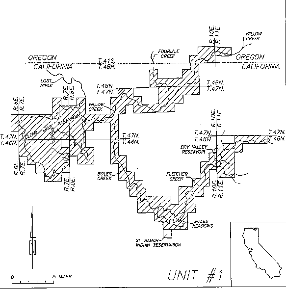
Unit Number: 1
Unit name: Clear Lake and watershed
Species: Shortnose sucker and Lost River sucker
Boundary Delineation: Modoc County, California, and Lake County, Oregon. All waters of Clear Lake Reservoir from reservoir bottom to highwater line (dam spillway) at elevation 4543.0 feet (USBR 1992) in T46N, R7E and R8E, and T47N, R7E and R8E. Then up Willow Creek from confluence with Clear Lake Reservoir (at high water) in T47N, R8E, Section 21, to "Bayley Tank" on Boles Creek (T46S, R11E, Section 29), Fletcher Creek upstream approximately to the intersection of Crowder Flat Road (T46S, R1OE, Section 24), and up Willow Creek (N. Fork, then E. Fork) to approximately the middle of Section 17 in T41S, R17E. Tributaries to Willow Creek included within critical habitat include Wildhorse Creek upstream to approximately the center of Section 32 in R1OE, T48N and Fourmile Creek upstream to the dam in Section 26 of R9E, T48N.
Shoreline Ownership: U.S. Fish and Wildlife Service, Clear Lake National Wildlife Refuge (25%). In watershed, USFS (66.75%), with private (8%) and State (0.25%) inholdings.
Occurrence Historical - Unknown, but presumed to have supported populations throughout this watershed. Migration corridors would have been more usable in the absence of dams used to hold water for summer cattle use, or irrigation, although in years of extreme high flows many such obstacles may be passable.
Recent - Scoppettone and Buettner collected suckers in this drainage described as SNS, and LRS have been found as far upstream as Avanzino Reservoir (Buettner pers. comm.). Surveys conducted in summer of 1993 collected juvenile suckers in the headwaters of Fletcher Creek (T46N, R11E, Section 1), and an adult sucker carcass that had presumably been "winter killed" in Fairchild Swamp (T44N, R1OE, Sections 29, 30, 31, and 32), although the latter habitat is not considered suitable for long-term survival (Yamigiwa pers. comm.).
Description of Habitat: Clear Lake Reservoir provides habitat sufficient to support large populations of both listed suckers. In collections between 1989 and 1993, length frequency histograms of both species showed a wide range of size classes indicating fairly consistent recruitment (Buettner and Scoppettone 1990, Buettner and Scoppettone 1991, USBR 1994). Habitat use in the lake is poorly understood, and few if any conclusions can be drawn about specific areas used in the lake. Water quality parameters have been monitored for several years by the Bureau of Reclamation, which manages the lake, and generally show that lower lake levels result in reduced water quality, increased stress on suckers, and reduced reproductive success (USBR 1994). The lake is largely a flat shallow basin with no particular natural structure or substrate features of note. The west lobe of the lake is deeper than the east lobe and is used as a refugial area by suckers at times of low water. Habitat condition in the upper watershed is unknown at this time. Habitats are largely stream habitats that provide suitable spawning areas for Clear Lake populations of both species. Resident populations are thought to exist in Avanzino Reservoir, and possibly in deeper pools in areas such as Boles Meadows.
Relationship to Constituent Elements
Water - This unit makes up the majority of the watershed for Clear Lake Reservoir, which is managed by the Bureau of Reclamation. Clear Lake is not as limited by the pH, nutrients, and temperature water quality components as is Upper Klamath Lake, but water quantity, timing of flow, lack of baseflow, and possibly sediment import issues are of concern. Restoring natural storage in wetlands and water tables within the watershed would improve water quality within the streams for resident populations (e.g., Avanzino Reservoir) through the stressful summer months, and probably in winter as well. Natural storage may also provide for higher base flows after the spawning migration in early spring to assist the return migration of large lake-resident adults to their lake habitats. The inclusion of the 100-year flood plain within the areas of critical habitat should provide protection for the necessary natural storage features.
Physical Habitat - Little instream habitat exists for resident populations, but this area is important for spawning migrations out of Clear Lake resevoir. The role of these stream habitats for spawning and rearing or migration of larval suckers is poorly understood. Specific spawning habitats have not been identified, but Buettner (pers. comm.) has indicated that the spawning migration cannot get past the Dam at Avanzino Reservoir. The presence of a sucker carcass in Fairchild Swamp does not necessarily indicate suitable habitat within the area. This carcass was found in a high flow year and may have strayed from suitable habitats into Fairchild Swamp, where it apparently was winter killed. Fairchild Swamp is not considered to be suitable sucker habitat (Yamigiwa, pers. comm.).
Biological Environment - Much of this watershed has been stocked with non-native predatory gamefishes that have probably altered the role of predation in larval recruitment. The availability of food items to larval or resident suckers is apparently suitable to support continued survival of the populations dependent on this watershed, although the specifics of food use and availability in this watershed have not been studied. Spawning was documented in spring of 1993, and juvenile suckers were collected in the summer of 1993, so suitable spawning and rearing habitat exists in this unit under at least some conditions.
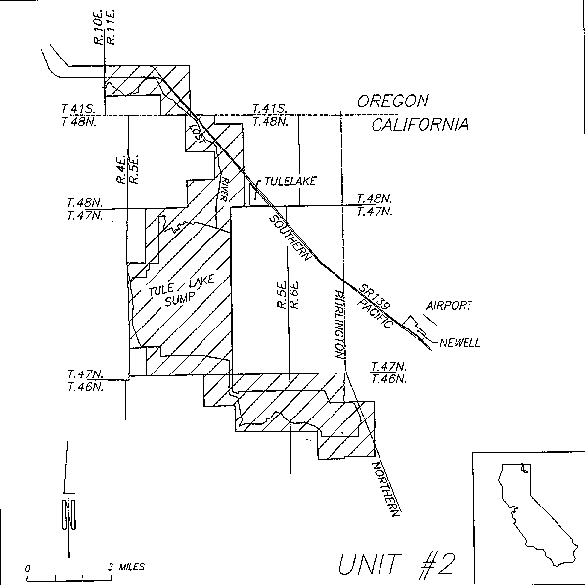
Unit Number: 2
Unit Name: Tule Lake
Boundary Delineation: Siskiyou County, California, and Klamath County, Oregon. Includes all waters in both basins of the Tule Lake sump from the highwater line at elevation 4036.0, as well as the Lost River upstream from Tule Lake to Anderson-Rose Dam in T41S, R11E, Section 7.
Shoreline Ownership: Fish and Wildlife Service Tule Lake National Wildlife Refuge (61.5 %), National Park Service (3 %), BLM (0.25 %), and Private (35.25 %).
Occurrence
Historical - Both the Lost River and shortnose sucker are considered native to Tule Lake (Moyle 1976, Scoppettone and Vinyard 1991). Little is known about the sucker populations inhabiting Tule Lake and the lower Lost River either before or after the construction of the Klamath Project, in part because neither was thought to provide suitable habitat until suckers were found in Tule Lake in recent years. Given the size of the historic Tule Lake and marsh complex, it likely provided suitable habitat for a very large population of both listed sucker species prior to alteration by the Bureau of Reclamation.
Recent - Recent surveys of Tule Lake began in 1992 after suckers were observed spawning at Anderson-Rose Dam where many were subsequently stranded and killed when flows were diverted for irrigation purposes. As a result of observing this spawning effort, interest in Tule Lake as a sucker habitat was renewed and the Bureau of Reclamation and the Service's Research Branch (now with the National Biological Survey) began monitoring the Tule Lake population. To date, little has been learned about the Tule Lake population beyond that it exists, and that the suckers inhabiting Tule Lake have an almost 50% higher condition factor (ratio of weight to length) over that of other populations. This is probably related to the high productivity of Tule Lake. Not enough suckers have been tagged and recaptured to allow a meaningful population estimate. There is no evidence that the Tule Lake population of either species has reproduced successfully in recent years. Year classes indicative of recent recruitment into the adult population have not been collected in significant numbers. However, recruitment gaps exceeding 10 years have been observed in other populations, so assuming that the Tule Lake population is incapable of reproducing on the basis of two years of surveys may be erroneous. Bureau of Reclamation surveys have indicated that spawning efforts at Anderson-Rose Dam have resulted in both viable eggs and even successful hatching of larvae. The availability of rearing habitats may be limited, however, in the Lost River. While it is possible that the Tule Lake population of both species represents an "orphan" population of suckers that have ended up in Tule Lake after passing through various features of the Klamath Project, it is also possible that this population is an otherwise viable population that is on the brink of collapse due to recruitment failure, poor habitat quality, and other impacts.
Description of Habitat - Tule Lake sump is a large, shallow lake that provides suitable habitat for normal behavior of adult suckers of both species. A spawning migration of adult suckers has been observed at Anderson-Rose Dam although no successful hatching from these spawning efforts has been documented. The lower Lost River between Tule Lake and Anderson-Rose Dam is a relatively shallow waterway confined by dikes that is primarily filled by waters backing up from Tule Lake.
Relationship to Constituent Elements
Water - This entire unit falls within the boundaries of the Bureau of Reclamation's Klamath Project. Tule Lake sump is the collection point for returning irrigation drainwater from the lower portions of the Project. Water quality in Tule Lake and the Lost River within this unit reflects the use that the water has been put to. During the irrigation season, water quality conditions can vary widely depending on nutrient enrichment from fertilizers or as a result of contaminants such as pesticides used on agricultural lands. During extreme water quality conditions, suckers radio tagged by the Bureau of Reclamation remain clustered in a single, small deep area near the middle of the upper sump (Green 1993). Water quality conditions in this small area appear to remain better and vary less on a daily basis than in the rest of the sump, and the area lacks the dense growths of aquatic macrophytes typical of the rest of the sump. This variation in aquatic plant growth appears to be related to a difference in the character of the bottom sediments in this small area. Because water quality coming into the Klamath Project is often bad, additional degradations in quality as a result of use on agricultural lands only worsen the water quality conditions in Tule Lake.
The quantity of water in Tule Lake is adequate for maintaining a small population of suckers, although depths in the lake through winter freezes may reduce the overall population size if water quality problems develop. Tule Lake is much more stable, in terms of surface elevations, than either Upper Klamath Lake or Clear lake Reservoirs. The timing and quality of flows at Anderson-Rose Dam are currently insufficient to support spawning migrations and to rear embryos.
Physical Habitat- Spawning habitat at the base of Anderson-Rose Dam is limited both by flows and the amount of suitable substrates. The Bureau of Reclamation is currently planning efforts to improve both the access to, and quality of, available spawning habitat under the flows currently available during the spawning period. Rearing habitat in the lower Lost River is limited both by water quality and structural features of the channelized river. The lower Lost River is, at high lake levels, made up almost entirely of backed-up lake water, and so water quality conditions reflect lake water quality parameters. A few small irrigation return drains empty into the river in this reach.
Biological Environment - The availability of food resources in Tule Lake appears to be excellent relative to other sucker habitats on the basis of the observed condition factors of Tule Lake suckers. Although no research has been conducted on the availability of such food sources as chironomid larvae, Tule Lake is considered to be the most productive sucker habitat in the Basin (Buettner pers. comm.). Recent surveys in Tule Lake have yet to document the presence of parasitic lampreys, so suckers in Tule Lake may be benefitting from the absence of a parasitic that stresses suckers in most other habitats.
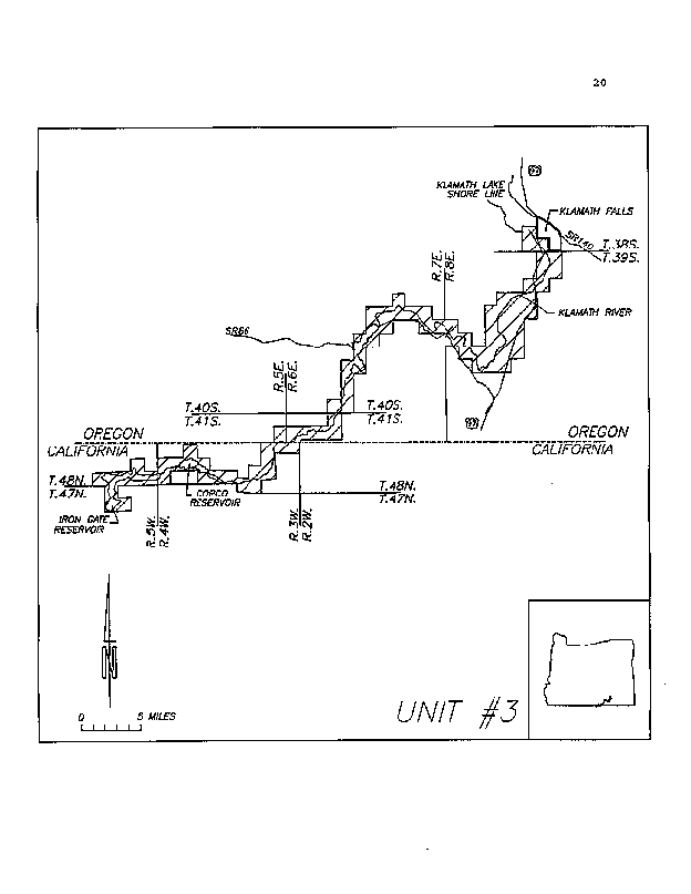
Unit Number: 3
Unit Name: Klamath River
Boundary Delineation: Siskiyou County, California, and Klamath County, Oregon. This unit begins at Link River Dam at Upper Klamath Lake in Township 38S, Range 9E., Section 30 of the Willamette Meridian, and extends down the Klamath River to Iron Gate dam in Township 47N., Range 5W., Section 9 of the Mt. Diablo Meridian. The unit includes the Klamath River and all 100-year floodplain areas as defined in the legal description of the proposed rule. This unit excludes the waters of any tributaries to the Klamath River along this reach, including Jenny Creek.
Species: Lost River sucker and shortnose sucker.
Shoreline Ownership: Forest Service (1.25%), BLM (15.5%), State (0.25%), and Private (83%).
Occurrence
Historic: Neither sucker species is described as being native to the Klamath River, particularly downstream of the Klamath Project's Klamath Straits Drain. Both species of suckers were probably frequently found in the Link River and Lake Ewauna as a result of their connections to Upper Klamath Lake and sucker populations resident therein. At times of extremely high flows, the Lost River connected to the Klamath River, and thus may have provided a means for moving suckers of both species from the Lost River system into the Klamath River. The current populations of suckers inhabiting the Klamath River may have become established as a result of reservoirs providing lake habitats that can support these species.
Recent: Lost River suckers have been found as far downstream in the Klamath River as Copco Reservoir (Beak 1987) and probably to Iron Gate Reservoir (Maria pers. comm. cited in USFWS 1993). Shortnose suckers have been collected in the Klamath River from Link River Dam to Copco Reservoir (USBR 1992). Almost no recent research has been conducted on the Klamath River populations of these species beyond incidental observations and the work of Beak (1987).
Description of Habitat: The Klamath River provides a variety of habitat types that support populations of unknown size and distribution of both Lost River and shortnose suckers. It is likely that portions of the river with significant flows do not contribute substantially to sucker habitats. Reaches of the river behind storage or diversion dams may provide suitable normal behavior habitats for suckers adapted to lake residence. The suitability of a given habitat may vary significantly over time as flows change with reservoir and river management. Specific areas for refugial, spawning, rearing, or other habitats are as yet unidentified.
Relationship to Constituent Elements:
Water - Portions of the Klamath River from Link River Dam to the Oregon/California border do not meet State of Oregon water quality standards (DEQ 1990). During the irrigation season, a large percentage of the flows in the Klamath River below the Klamath Straits Drain consists of irrigation return water. Water quality in these reaches is thus largely impacted by the poor water quality of irrigation return water as supplemented by water reentering the river from Upper Klamath Lake. Water quality in Lake Ewauna seasonally drops to extreme lows in terms of dissolved oxygen, making this habitat virtually inhospitable to suckers. At these times, such as in the mid- to late-summer, suckers inhabiting Lake Ewauna are thought to move upstream to the more oxygenated waters of the Link River. Water temperatures throughout the Klamath River in this unit get very high in the summer months as flows are restricted to provide irrigation supplies to the Klamath Project. Water returning to the River from the Project is warm and carries increased nutrients and possibly contaminants over the water emanating from Upper Klamath Lake. Flows in the river through this unit are tightly controlled by reservoir, Project, and river management agencies. Water quality in this unit is more dependent upon river and reservoir management, and Project-related irrigation use, than to natural features such as riparian areas and wetlands, although there may yet be unexplored opportunities to establish riverine wetlands throughout this unit to assist in maintaining water quality. Water quality conditions in the Klamath River throughout this unit are periodically variable and can be very poor (Federal Energy Regulatory Commission 1990; National Park Service 1994).
Physical Habitat: Physical habitats in this unit are characterized by a series of reservoirs for hydropower use alternating with free flowing stretches of river. With the exception of migrations for spawning or in seeking out water quality refugia, the listed suckers probably stay in the reservoirs the majority of the time. The reservoirs have not been studied closely to determine exact habitat availability and use by suckers, but are likely to provide habitats for most life history stages for the listed suckers. Wetland areas are available in some stretches of the river, particularly near Lake Ewauna, but the extent to which these areas provide suitable rearing habitat or water quality improvement or maintenance is unknown.
Biological Environment: Food supplies throughout this unit are not expected to be a limiting factor, as the river is well enriched from algal and human related nutrient sources. The availability of specific food sources at the times needed by a given life stage of suckers is unknown. Predation in this unit is probably not significantly different from what might have occurred historically since the gamefish present are primarily trout. Competition from introduced fishes, such as golden shiner, Notemigonus crysoleucas, fathead minnow, Pimephales promelas, and Sacramento perch, Archoplites interruptus, may impact sucker populations in the river.
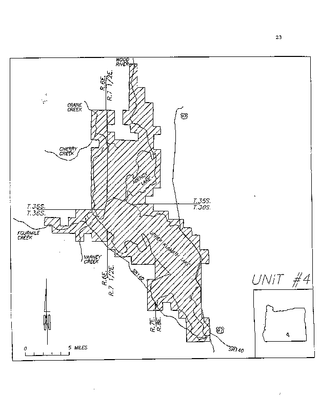
Unit Number: 4
Unit Name: Upper Klamath Lake
Species: Lost River and shortnose suckers.
Boundary Delineation: Klamath County, Oregon. This unit begins at Link River Dam at Upper Klamath Lake in Township 38S, Range 9E., Section 30 of the Willamette Meridian. It includes Upper Klamath Lake Reservoir (including Agency Lake) from the reservoir bottom to the highwater line of 4145 feet surface elevation. It also includes the 100-year floodplain areas as defined in the legal description of the proposed rule. Portions of both Fourmile Creeks, Crystal Creek, Wood River, Fort Creek, and Crooked Creek drainages. This unit specifically excludes all portions of the Williamson River below the highwater line of Upper Klamath Lake reservoir and its watershed as these areas are included in another unit.
Shoreline Ownership: Forest Service (15.5%), BLM (1.75%), Fish and Wildlife Service (14%), State (0.25%), and Private (68.5%).
Occurrence
Historical - Both the Lost River sucker and the shortnose sucker are described as being native to Upper Klamath Lake (Williams et al. 1985), its tributaries, including Wood River, Crooked Creek, Seven Mile Creek, Four Mile Creek and slough, Odessa Creek, and Crystal Creek (Stone 1982). Within Upper Klamath Lake, isolated stocks of Lost River suckers have utilized springs such as Sucker Springs, Harriman Springs, Barkley Springs, and possibly other lakeshore springs for spawning and egg incubation. All but the Sucker Springs stock have disappeared (USFWS 1993). Large wetland areas that were historically connected to Upper Klamath Lake may have served as water quality Refuge areas or as larval and/or juvenile rearing areas for both sucker species.
Current - Both Lost River and shortnose suckers are still found in Upper Klamath Lake and its tributaries (Scoppettone and Buettner 1990, Markle and Simon 1993). An isolated stock of Lost River suckers, and possibly of shortnose suckers, spawns at Sucker Springs on the eastern shore of Upper Klamath Lake. Larval suckers have been collected from the Wood River system (Markle and Simon 1993) and may be the offspring of a run of suckers from Upper Klamath or Agency Lakes. Extensive survey work has not been conducted in all of the smaller tributaries of both lakes, but these areas are within the likely range of both species (Klamath Tribe, unpublished data).
Description of Habitat - Upper Klamath Lake and Agency Lake provide a wide variety of habitat types for all life stages of both species. These include, but are not limited to, feeding habitats, water quality refugial habitats, spawning habitats in spring areas, normal behavior habitats, and migration areas between these habitats. The wetland margins of both lakes, and much of the 100 year floodplain areas included within the proposed unit, also provide important areas for the provision and maintenance of water quality. Spring sources provide important inflows of high quality water that is vital to maintaining water quality refugia in stressful summer conditions.
Relationship to Constituent Elements
Water - Water quality conditions in Upper Klamath Lake have been the focus of intense scrutiny by researchers from a variety of agencies, as well as by individuals who are impacted by the management of Upper Klamath Lake, and are discussed in detail above under Justification for Primary Constituent Elements. Water quality conditions in Upper Klamath Lake, as measured by such variables as dissolved oxygen, can vary widely, even within a span of a few hours. The complex dynamics of algal population growth, peak, and then crash, which drive changes in water quality conditions over the short term, occur within the broader context of a trend toward losses of lake margin and riverine wetlands that could serve to improve water quality conditions over the long term. Changes in the timing and amount of flows received from the tributary watershed to Upper Klamath Lake has effects on algal population dynamics, and thus on water quality, that are in turn complicated by the reservoir management. Consequently, poor water quality conditions in Upper Klamath Lake, as described earlier in this document, are likely to continue until significant improvements in the amount, availability, and quality of lake margin and riverine wetlands occur. In the mean time, the maintenance of water quality refugial areas, such as Pelican Bay and the springs that feed it, will continue to be vital to the short and long-term survival of the Upper Klamath Lake populations of both sucker species.
Physical Habitat - Important physical habitats in Upper Klamath Lake include spawning areas at Sucker Springs, Barkley Springs, and other spring sources, larval and juvenile rearing areas along the margins of the lake, particularly near the mouth of the Williamson River and other spawning migration corridors, normal behavior habitats, water quality refugial habitats, feeding areas, and migration corridors between all these habitats.
Biological Environment - The biological environment of Upper Klamath Lake has been under a long term change from a eutrophic lake harboring a variety of algal species that progress through a cycle of dominance in a given year to a hypertrophic lake dominated by a single algal form for the majority of the summer. Because of fish kills associated with algal population die-offs, native fish species in Upper Klamath Lake may be stressed to the extent that their populations have been made more susceptible to the impacts of exotic predators or competitors. In recent years, the fathead minnow, Pimephales promelas, has become the single most common fish species collected in fish surveys of Upper Klamath Lake (Markle and Simon 1993). Fathead minnows are known to prey on sucker larvae in the laboratory (Dunsmoor 1993), and may serve as predators or at least extremely abundant competitors to wild larval and juvenile suckers in the lake. The impacts of other exotic fishes, such as largemouth bass, yellow perch, white sturgeon, and hatchery planted rainbow trout, are unknown. The availability of food supplies is probably not limited in such a nutrient rich environment as Upper Klamath Lake, although it is possible that certain life stages of suckers may not find suitable food supplies under certain habitat or water quality conditions.
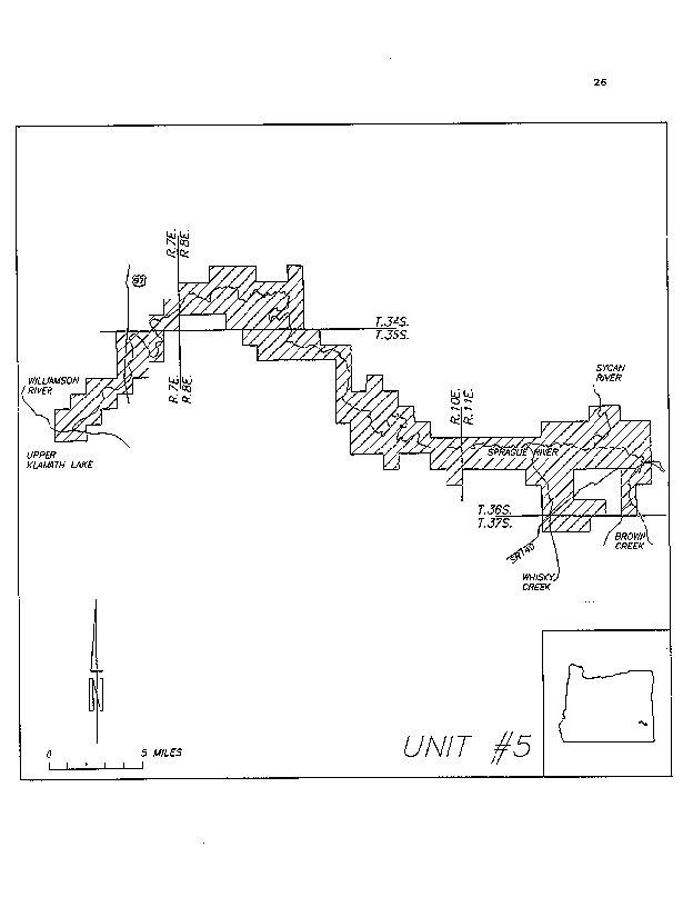
Unit Number: 5
Unit Name: Williamson and Sprague Rivers Species: Lost River and shortnose suckers.
Boundary Delineation: Klamath County, Oregon. This unit begins at the confluence of the Williamson River and Upper Klamath Lake in Township 36S, Range 71/2E, Section 11 of the Willamette meridian. The unit then extends up the Williamson River to the confluence of the Sprague River, in Township 35S., Range 7E., Section 3, then up the Sprague River to the presumed limit of historic distribution at the confluence of Brown Creek in T R S. The unit includes 100-year floodplains along both the Williamson and Sprague Rivers, as well as some of their tributary streams. This unit specifically includes all portions of the Williamson River below the highwater line of Upper Klamath Lake reservoir.
Shoreline Ownership: Forest Service (20.0%), BLM (0.5%), and Private (79.5%).
Occurrence
Historical - Both the Lost River sucker and the shortnose sucker are described as being native to the Williamson and Sprague Rivers, although there were probably not ever entirely river resident forms of Lost River suckers at any time. The Williamson and Sprague Rivers served primarily as spawning and possibly rearing areas for both sucker species prior to the building of Chiloquin Dam and the channelization of the Sprague River. The Sprague River watershed also provided the majority of flows entering Upper Klamath Lake that triggered spawning migrations, and that brought in nutrients to support the historic algal populations and species. Prior to the loss of normal watershed function in the Sprague system, when summer baseflows were higher, spring flood flows were lower, and water quality in the river itself was much more stable, the river may have provided significant habitat for river resident shortnose suckers and helped provide more stable water quality conditions in Upper Klamath Lake. Riverine wetlands along both rivers probably contributed greatly to maintaining water quality in the rivers and entering the lake.
Current - Currently, the Williamson and Sprague Rivers are used almost exclusively by Lost River and shortnose suckers as spawning habitat, spawning migration routes, and larval rearing and outmigration corridors. The reduced availability of suitable spawning habitat upstream of Chiloquin Dam has resulted in an effective reduction in range of both species. Although Chiloquin Dam is fitted with a fish ladder that passes suckers, few are observed to migrate past the dam, presumably because of reduced availability of suitable spawning habitats or migration corridors to those habitats that still exist.
Relationship to Constituent Elements
Water - Water quality in this unit is determined largely by the availability of water to the lower Sprague River from its upper watershed areas. Because of extensive impacts to the watershed from such practices as timber harvest, grazing, road building, channelization of the river to drain wetlands for agricultural use, and agricultural diversions, the Sprague River does not meet state water quality standards (DEQ 1992). The Sprague River provides a major portion of the inflows to Upper Klamath Lake, so poor water quality conditions in the Sprague River contribute to, or exacerbate, poor water quality conditions in Upper Klamath Lake. Improving summer baseflows and reducing spring flood flows in the Sprague River watershed would very likely assist in managing the algal dynamics of Upper Klamath Lake with their associated water quality problems as described above. To improve the timing and quantity of flows in the Sprague River, areas of the river currently channelized away from their natural flood plains may need to be reconnected. Additional water quality concerns exist in the lower Williamson River near its confluence with Upper Klamath Lake. This area serves as a water quality refugial area for adult suckers inhabiting the lake during times of stressful water quality conditions in the lake.
Physical Habitat - Habitats in the Sprague and Williamson are currently limited to the water quality refugial habitat at the mouth of the Williamson River, and the migration corridor up the Williamson to the spawning habitats at Chiloquin Dam on the Sprague River. There may be some isolated spawning habitats further upstream under high flow conditions, but water quality in the Sprague above the dam often limits access to and from these areas. The habitat conditions of the Sprague River itself are largely poor, as the channelized streambed has lost much of its channel complexity and structural features that the suckers have adapted to. Spawning and rearing habitat in the lower Sprague and Williamson Rivers may be limiting because of the short distance of river and large number of suckers attempting to use the area. The physical features of the Williamson between the confluence with the Sprague and Upper Klamath Lake are such that the habitat, while important for larval rearing and migration, is far from optimal for either. The timing and amount of flows in both rivers impacts the availability of suitable habitats for all life stages.
Biological Environment - The lower portions of the Williamson River closely resemble the conditions of Upper Klamath Lake, and in fact fall within the upper limits of the reservoir's surface. There, fathead minnows may act as competitors with, or predators upon, Lost River and shortnose sucker larvae migrating down into the lake (see Biological Environment in the Upper Klamath Lake unit description). Degraded habitat and water quality conditions upstream in the Sprague River favor introduced warmwater fishes and thus may result in increased predation. While adult suckers are probably not feeding while entering the rivers to spawn, the availability of food resources to larval outmigrating suckers may be important to their ability to survive and compete in the lake environment.
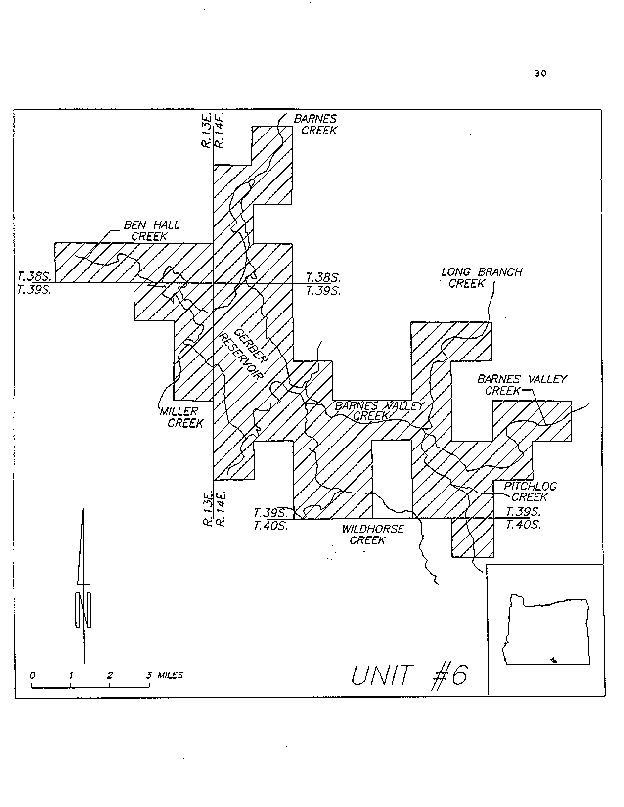
Unit Number: 6
Unit name: Gerber Reservoir and watershed
Species: Shortnose sucker (Gerber Reservoir is the only critical habitat unit proposed for just the shortnose sucker. No Lost River sucker critical habitat has been proposed in the Gerber Basin.)
Boundary Delineation: Klamath and Lake Counties, Oregon. All waters of Gerber Reservoir from reservoir bottom to highwater line at elevation 4835.4 feet (USBR 1992), and tributaries as listed: Ben Hall Creek from its origin in T38S, R13E, Section 33 to its confluence with Gerber Reservoir. Long Branch Creek from the confluence with Barnes Valley Creek in Section 24 of T39S, R14E, upstream to the confluence of unnamed tributary in T39S, R15E, Section 6. Barnes Valley Creek from the confluence with Gerber Reservoir in Section 21 of T39S, R14E, upstream to approximately the center of Section 21 of T39S, R15E. Pitchlog Creek upstream from confluence with Barnes Valley Creek in Section 24 of T39S, R14E, to approximately the center of T40S, R15E, S6. Barnes Creek from its confluence with Gerber Reservoir in Section 19 of T38S, R14E upstream to its origin in Section 17 of the same Township and Range. Wildhorse Creek and unnamed tributary from confluence with Gerber Reservoir in Section 21 of T39S, R14E, to their respective road crossings in Sections 34 and 27 of the same Township and Range.
Shoreline Ownership - BLM (72.5%), USFS (12%), State (3.5%) and private (12%).
Occurrence Historical - The population of shortnose suckers that inhabit Gerber Reservoir and its tributaries is thought to have been introduced, but the timing of that introduction is unknown (USFWS 1993). Regardless of whether it was an historic population, the Gerber population is considered important to the species as a whole because it is one of the few populations of shortnose suckers showing consistent recruitment.
Recent - In the Gerber Reservoir watershed, shortnose suckers have been observed or captured in Gerber Reservoir, Barnes Valley Creek, Ben Hall Creek, Pitch Log Creek, and Long Branch Creek (Buettner pers. comm.). Shortnose suckers that were presumably washed through Gerber Dam have also been collected in Miller Creek below Gerber Reservoir during salvage operations in 1992. In the Gerber Reservoir watershed, shortnose suckers spawning runs have been observed in Barnes Valley Creek, Ben Hall Creek, Pitch Log Creek, and Long Branch Creek (Buettner pers. comm.). Little is known about the endangered sucker population inhabiting Gerber Reservoir. In May 1992, over 200 shortnose suckers were salvaged from Gerber Reservoir. They ranged in size from 78 to 461 mm fork length (FL). The presence of smaller suckers indicates that the population of shortnose suckers in Gerber reservoir has successfully recruited in recent years (Buettner pers. comm.). Juvenile suckers (less than 100 mm FL) were observed in Barnes Valley Creek in 1992, indicating successful reproduction in the creek in 1991 (Buettner pers. comm.). Successful spawning runs from the reservoir were unlikely in 1992 due to very low flows in tributaries (Buettner pers. comm.). Gerber reservoir was drawn down to critically low levels for irrigation releases in 1991 and 1992. Gerber reservoir reached a minimum elevation of 4796.37 feet (182 surface acres, 835 acre-feet) in October 1992, which is less than 1 % of the reservoir's capacity. The reservoir did maintain a population of suckers, but aeration was necessary to improve water quality from June 1 - October 5 of 1992 and February 5 - March 10, 1993. Dissolved oxygen levels fell to as low as 2.96 mg/1 and were frequently less than 5 mg/1 during these time periods (Reclamation unpublished data). The shortnose suckers sampled in April, 1992, showed signs of stress such as low body weight, poor gonadal development, and reduced growth rates of juveniles, which were probably related to low reservoir levels (Buettner pers. comm.). A survey conducted during late October and early November of 1992, indicated further degradation in condition factors of the shortnose suckers sampled (Buettner pers. comm.). Despite their poor condition, shortnose sucker spawning runs were observed in Barnes Valley Creek, Ben Hall Creek, Barnes Creek, Pitch Log Creek, and Long Branch Creek in 1993 and larval suckers were observed in the creeks (Buettner pers. comm.).
Description of Habitat - Gerber Reservoir provides lake habitat supporting a population of large adult shortnose suckers as is typically found in other lake habitats in the basin. No estimates have been made of the size of the shortnose sucker population in Gerber Reservoir, although large numbers have been observed in the spawning runs. The Gerber watershed provides spawning habitat in, at least, Barnes Valley Creek, Ben Hall Creek, Pitch Log Creek, and Long Branch Creek (Buettner pers. comm.). Additionally, stream resident populations may occur in these creeks where habitat is suitable through both summer and winter; stress periods. Forest Service personnel have documented stream resident shortnose suckers in Lapham Creek, where at least three and possibly four year classes of suckers were observed in association with check dam formed pools (Nichols pers. comm.). Spawning areas, rearing areas, and other habitats are not yet mapped in the Gerber Basin.
Relationship to Constituent Elements
Water - This entire unit falls within the watershed boundary for Gerber Reservoir, which is managed by the Bureau of Reclamation. Water quality in Gerber Reservoir was documented as being poor during the extended drought conditions of 1992 when the reservoir reached a minimum surface elevation of 4796.37 feet. Aeration was necessary to improve water quality in the reservoir at this low level. Shortnose suckers collected during a spawning migration in Spring of 1993 showed signs of severe stress probably related to low reservoir levels (Buettner pers. comm.). At times when the reservoir is at higher surface elevations, the water quality may be sufficient to provide for the needs of shortnose suckers, but little water quality monitoring has occurred under these conditions. The streams of the Gerber watershed have been degraded due to the cumulative effects of logging, grazing, road building, and other watershed impacting practices (DEQ 1992). The loss of healthy riparian areas and the relationship between riparian areas and associated wet meadows and water tables has reduced summer base flows. Restoring natural storage within the watershed would improve water quality within the streams for resident populations through the stressful summer months, and may provide for higher flows after the spawning migration in early spring to assist the return migration of large, lake-resident adults to their lake habitats.
Physical Habitat - The details of habitat use within Gerber Reservoir are poorly understood, if at all. All that can be documented is that shortnose suckers have persisted in the reservoir in the past, and that they use streams in the watershed for spawning. Spawning migrations were observed in the spring of 1992 and 1993. Spawning migration activity has been documented in Barnes, Long Branch, Barnes Valley, Pitchlog, Ben Hall, and Wildhorse Creeks. It is not clear whether adult, lake-resident suckers can reside in any of the small reservoirs that exist in the watershed. Little is known about the abundance, distribution, or access to spawning and rearing habitats in these streams or the reservoir.
Biological Environment - The presence of piscivorous exotic fishes in Gerber Reservoir has likely impacted the recruitment success of shortnose suckers inhabiting the reservoir, particularly during reservoir drawdowns related to irrigation deliveries and/or drought conditions. However, no one has documented predation by these fishes on shortnose suckers in the wild (but see Dunsmoor 1993), nor is there specific information on the relationship between reservoir levels and the potential for predation within Gerber Reservoir. Degraded habitat conditions in the Gerber Basin streams will continue to favor warmwater gamefishes and thus likely prevent significant improvements in recruitment to the lake or stream populations. The availability of food supplies in the Gerber Basin does not appear to be a limiting factor at this time.
Baltz, D.M., and P.B. Moyle. 1993. Invasion resistance to introduced species by a native assemblage of California stream fishes. Ecological Applications 3(2)pp. 246-255.
Barica, J. 1980. Why hypertrophic ecosystems? in J. Barica and L.R. Mur, Eds., Hypertrophic ecosystems. Develop. Hydrobiol. 2:1-3.
Beak Consultants Incorporated. 1987. Shortnose and Lost River Sucker Studies: Copco Reservoir and the Klamath River. Report Prepared for the City of Klamath Falls, Oregon. June 30, 1987. 55 pp.
Buettner, M. and G. Scoppettone. 1990. Life history and status of catostomids in Upper Klamath Lake, Oregon. U.S.F.W.S Completion Report. 108 pp.
Buettner, M. and G. Scoppettone. 1991. Distribution and Information on the Taxonomic Status of the Shortnose Sucker, Chasmistes brevirostris, and Lost River Sucker, Deltistes luxatus, in the Klamath Basin, California. Completion Report. CDFG Contract FG-8304. 101 pp.
Burns, D.C. 1991. Cumulative effects of small modifications of habitat. Fisheries 16: 12-17.
Chaney, E., W. Elmore, and W.S. Platts. 1990. Livestock Grazing on Western Riparian Areas Prepared for the U.S. EPA. 45 pp.
Chesters, G., and L. Schierow. 1985. A primer on nonpoint pollution. Journal of Soil and Water Conservation Jan-Feb, 1985:9-13.
Coats, R.N., and T.O. Miller. 1981. Cumulative silvicultural impacts on watersheds: a hydrologic and regulatory dilemma. Environmental Management 5:147-160.
DEQ (Oregon Department of Environmental Quality). 1992. Oregon's 1992 Water Quality Status Assessment Report: 305(b) Report. DEQ. 811 S.W. Sixth Avenue, Portland, Oregon 97204.
Duda, A.M. 1985. Environmental and economic damage caused by sediment from agricultural nonpoint sources. Water Resources Bulletin 21 :225-234.
Dunsmoor, L. 1993. Laboratory Studies of Fathead Minnow Predation on Catostomid Larvae. Klamath Tribes Research Report: KT-93-01. 16 pp.
Elmore, W. in press Riparian responses to grazing practices. Chapter 17 in Watershed Management. Springer-Verlag pp. 442-457.
Elmore, W., and R.L. Beschta. 1987. Riparian areas: perspectives in management. Rangelands 9:260-265.
Federal Energy Regulatory Commission. 1990. Final Environmental Impact Statement for the Salt Caves Hydroelectric Project. Washington, D.C.
Falter, M. A. and J.J. Cech. 1991. Maximum pH tolerance of three Klamath Basin Fishes. Copeia (4)1109-1111.
Gilbert, C.H. 1898. The fishes of the Klamath Basin. Bull. U.S. Fish Comm. 17(1897):1-13.
Green, D. M., and J. B. Kauffman. 1989. Nutrient cycling and the land-water interface: the importance of the riparian zone. In Practical Approaches to Riparian Resource Management. May 8-11, 1989. Billings, Montana.
Green, M. 1993. Presentation at Klamath Sucker Research Coordination Meeting, 5 August 1993. U.S. Bureau of Reclamation, Klamath Project, 6600 Washburn Way, Klamath Falls, OR, 97602-9365.
Gregory, S., and L. Ashkenas. 1990. Riparian Management Guide for Willamette National Forest. 120 pp.
Gregory, S.V., F.J. Swanson, W.A. McKee, and K.W. Cummins. 1991. An Ecosystem Perspective of Riparian Zones. BioScience 41(8)540-551.
Johnson, J.E., M.G. Pardew, and M.M. Lyttle. 1993. Predator recognition and avoidance by larval razorback sucker and northern hog sucker. Trans. of the American Fisheries Society 122:1139-1145.
Kann, J., and V.H. Smith. 1993. Chlorophyll as a predictor of elevated pH in a hypertrophic lake: estimating the probability of exceeding critical values for fish success. Klamath Tribes Research Report: KT-92-02. 22 pp.
Karr, J.R., and I.J. Schlosser. 1978. Water resources and the land-water interface. Science 201 :229-234.
Klamath Tribe. 1991. Effects of water management in Upper Klamath Lake on habitats important to endangered catostomids. Internal Rept., The Klamath Tribe, Chiloquin, OR. 7 pp.
Knight, A. W. and R. L. Bottorf. 1984. The importance of riparian vegetation to stream ecosystems, pp. 160 167. In, R.E. Warner and K. M. Hendrix (Eds.), California Riparian Systems: Ecology, Conservation, and Productive Management. University of California Press, Berkeley.
Lowrance, R., R. Todd, J. Fail Jr., O. Hendrickson, Jr., R. Leonard, and L. Asmussen. 1984. Riparian Forests as Nutrient Filters in Agricultural Watersheds. BioScience 34:374-377.
Maloney, T.E., W.E. Miller, T. Shiroyama. 1972. Algal responses to nutrient additions in natural waters. I. Laboratory assays. Nutrients and Eutrophication Special Symposia 1: 134-140.
Markle, D.F., and D.C. Simon. 1993. Preliminary studies of systematic and juvenile ecology of Upper Klamath Lake suckers. Final Report published by Oregon State University, Corvallis. 129 pp.
Meehan, W.R., editor. 1991. Influences of forest and rangeland management on salmonid fishes and their habitats. American Fisheries Society Special Publication 19.
Miller, W.E., and J.C. Tash. 1967. Interim Report, Upper Klamath Lake studies, Oregon. Pacific Northwest Water Laboratory, Federal Water Pollution Control Administration. Water Pollution Control Research Series No. WP-20-8.
Mitsch, W.J., and J.G. Gosselink. 1986. Wetlands. Van Nostrand Reinhold, New York. 539 pp.
Monda, D., and M. Saiki. 1993. Tolerance of juvenile Lost River and Shortnose suckers to high pH, ammonia concentration, and temperature, and to low dissolved oxygen concentration. Final Report prepared for U.S. Bureau of Reclamation, Klamath Falls, Oregon, and Denver, Colorado. U.S. Fish and Wildlife Service, National Fisheries Contaminant Research Center, Dixon, California.
Monda, D., and M. K. Saiki. 1994. Tolerance of juvenile Lost River to high pH, ammonia concentration, and temperature, and to low dissolved oxygen concentration. Final report submitted to U.S. Bureau of Reclamation, Klamath Falls, OR.
Moyle, P.B. 1976. Inland Fishes of California, Univ. California Press, Berkeley, CA. 405 pp.
Moyle, P.B., and R.A. Leidy. 1992. Loss of Biodiversity in Aquatic Ecosystems: Evidence from Fish Faunas in Conservation Biology: The Theory and Practice of Nature, Conservation, Preservation and Management. P.L. Fielder and S.K. Jain, Eds. New York: Chapman and Hall.
Moyle, P.B., and G.M. Sato. 1991. On the design of preserves to protect native fishes. Pgs. 155-169 in W.L. Minckley and J.E. Deacon (eds.). Battle Against Extinction: Native Fish Management in the American West. University of Arizona Press, Tucson and London.
National Park Service. 1994. Klamath Wild and Scenic River Eligibility Report and Environmental Assessment. Pacific Northwest Region, Seattle, WA. 108 pp.
Oregon State University. 1984. Riparian Zone Systems, Uses, and Management Honey, W. D., R.J. Seidler, and P.C. Klingeman (eds). Final Technical Completion Report for Project Number 373922. Submitted to U.S. Geological Survey. Reston, Virginia.
Panek, F.M. 1979. Cumulative effects of small modifications of habitat. Fisheries 4:54-57.
Peterjohn, W.T, and D.L. Correll. 1984. Nutrient dynamics in an agricultural watershed: observations on the role of a riparian forest. Ecology 65:1466-1475.
Platts, W.S. 1991. Livestock Grazing. American Fisheries Society Special Publication 19:389423.
Reeves, G.R., and J.R. Sedell. 1992. An Ecosystem Approach to the Conservation and Management of Freshwater Habitat for Anadromous Salmonids in the Pacific Northwest in Transactions of the 57th North American Wildlife and Natural Resources Conference, Special Session 6. J. E. Williams and R.J. Neeves, co-chairs. Wildlife Management Institute, Washington, D.C.
Reichmuth, D. R. 1986. Fluvial systems in the wetland environment. pp. 23-59 in Great Basin/Desert and montane regional wetland functions. Workshop Proceedings. Publication No. 904. University of Massachusetts, Amherst.
Ricklefs, R. E. 1979. Ecology. Second Edition. Chiron Press, Inc. New York. 966 pages.
Schlosser, I.J. 1991. Stream fish ecology: a landscape perspective. BioScience 41:704-712.
Schlosser, I.J., and J.R. Karr. 1981. Water quality in agricultural watersheds: impact of riparian vegetation during base flow. Water Resources Bulletin 17:233-240.
Scoppettone, G.G., and G.L. Vinyard. 1991. Life History and Management of Four Endangered Lacustrine Suckers. Pgs. 359-377 in W.L. Minckley and J.E. Deacon (eds.). Battle Against Extinction: Native Fish Management in the American West. University of Arizona Press, Tucson and London.
Simpson, P. W., J.R. Newman, M.A. Kevin, R.M. Matter, and R.A. Guthrie. 1982. Manual of stream channelization impacts on fish and wildlife. U.S. Fish and Wildlife Service, Office of Biological Services, Rep. 82/24. Washington D.C.: U.S. Fish and Wildlife Service.
Stine, P.A. 1982. Preliminary Status Report on the Lost River Sucker. Report to Panel Members of the Endangered Species Office, USFWS. 23 pp.
U.S. Bureau of Reclamation. 1992. Biological Assessment on the Effects of Long-Term Operation of the Klamath Project. Sacramento, California.
U.S. Bureau of Reclamation. 1994. Biological Assessment for Reinitiation of Formal Consultation on the Long Term Biological Opinion for the Operation of the Klamath Project (Clear Lake Reservoir Operations). Klamath Project, Klamath Falls, Oregon.
U.S. Department of Agriculture, U.S. Department of the Interior, U.S. Department of Commerce, and the Environmental Protection Agency. 1993. Forest Ecosystem Management: An Ecological, Economic, and Social Assessment. Report of the Forest Ecosystem Management Assessment Team. Forest Service, Fish and Wildlife Service, National Marine Fisheries Service, National Park Service, Bureau of Land Management, Environmental Protection Agency.
U.S. Fish and Wildlife Service. 1993. Lost River (Deltistes luxatus) and shortnose (Chasmistes brevirostris) Sucker Recovery Plan. Region 1, U.S. Fish and Wildlife Service, Portland, Oregon. 95 pages.
Williams, J.E., D.B. Bowman, J.E. Brooks, A.A. Echelle, R.J.Edwards, D.A. Hendrickson, and J.J. Landye. 198S. Endangered Aquatic Ecosystems in North American Deserts with a List of Vanishing Fishes of the Region. Journal of the Arizona-Nevada Academy of Science 20:1-62.
Nichols, B. 1994. U.S. Forest Service, Fremont National Forest. Bly Ranger District, Bly, Oregon.
Yamigiwa, M. 1994. U.S. Forest Service, Modoc National Forest, Alturas, California.