Bibliography Background About KRIS
Geology of North Coastal California
 Northwestern California has been shaped by the forces of plate tectonics. This process causes plates of the Earth's crust to collide, resulting in uplifting of the land, great earthquakes and major geologic instability (Carver and Burke, 1987; Hardin, 1997)). Until plate tectonics were discovered in the 1970's, the varied assemblage of rock types in the Coast Range was a puzzle to geologists but it has now been recognized that the rocks are remnants of vast areas of the sea floor and fragments of the continental margin (Hardin, 1997). This complex formation was broadly categorized as the Franciscan formation but several distinct terrains are now recognized. (See description.)
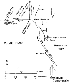
The best known geologic feature in northern California is the San Andreas fault (Oakshott, 1972), which extends north along the coast from San Francisco and ends at the "Triple Junction" offshore of Cape Mendocino. The Triple Junction is where the American Plate, Pacific Plate and the Gorda Plate meet. Earthquake hazards are greater to the north of the San Andreas fault because this region is part of the Cascadia subduction zone, where plate collisions increase the potential for huge earthquakes.
 Two to three million years ago the Triple Junction was closer to Fort Bragg, but it has been moving steadily north (Hardin, 1997). As the subduction zone migrates north, compression of the crust south of the Triple Junction has shifted. Instead of the east-west orientation which caused the formation of the Coast Range, the compression now is from north to south (Kramer, 1974) which drives the continental plate south against the north-trending San Andreas. This compression causes ridges and valleys (anticlines and synclines) to form in an east-west trending pattern (see graphic above).
Tectonic forces drive the Gorda Plate into the American Plate, pushing the Gorda under the American. Every 300 to 600 years, earthquakes measuring 9.0 or greater on the Richter scale completely reform the landscape, releasing the great pressures built up by the collision. The plate collisions compress the edge of the American Plate, causing substantial uplifting and the ongoing formation of the Coast Range with ridges and valleys trending north-south. This orientation of the Coast Range also continues to the south due to the San Andreas Fault.
 This graphic, from the California Division of Mines and Geology, is derived from Kilbourne (1983, 1984) and can be viewed in the KRIS Noyo Map project. It shows the different types of active and dormant landslides in the upper Noyo Basin. Due to the orographic effect, the steep Coast Range intensifies rainfall as Pacific storms hit the coast (see Precipitation ). The combination of weak bedrock geology, an over-steepened landscape and high rainfall make for extremely high erosion risk (Judson and Ritter, 1964).
The San Andreas fault runs offshore near the town of Point Arena to its terminus near Cape Mendocino. It is a major force in shaping the landscape of the Mendocino coast. The land mass on the west side of the fault, part of the Monterey formation, has been transported hundreds of miles north, while the geology east of the fault is part of the Franciscan formation (Elder, 1976).
During the 1906 earthquake, portions of fences and roads were offset by up to16 feet in Mendocino County. The trace of the San Andreas fault can be easily identified by the many slump and sag ponds along its route caused by shearing. The branches of the Garcia and Gualala rivers, as well as Tomales Bay, follow directly on the fault. Slumps and slides along the fault during large earthquakes can profoundly alter the course of these streams. After large earthquakes, the likelihood of subsequent landslides across the entire landscape is elevated.
"Continuing detailed studies of the Franciscan have created an even more complex picture of its formation. It appears that Franciscan rocks represent not one but several, accreted terrains. These separate Franciscan blocks represent the remnants of several oceanic plates that met their end against the edge of the North America. So far, at least nine different blocks or terrains have been identified. Studies of radiolaria contained in the chert, paleomagnetic analysis of limestone and detailed studies of the mineral content of the greywacke sandstones are some of the tools that geologists are using to complete this picture.
The area where Franciscan rocks are seen can be broadly divided into three belts. In the Coastal Belt, a northwest trending zone between Eureka and the Russian River, Franciscan rocks are mainly greywacke and shale sequences that are not disrupted as other parts of the Franciscan. The Central Belt, including the San Francisco Bay Area, is found east of the Coastal Belt and this part of the Franciscan Assemblage is a jumble of rocks. Isolated small blocks of exotic greenstone, blueschist, eclogite, chert or greywacke 'float' in a matrix off highly sheared mudstone. Geologists term this mixture a mélange, adopting a cooking term used to describe a soup that contains floating chunks of goodies. In the Franciscan mélange, the 'soup base' or matrix of sheared mudstone, and the floating chunks are blocks of more resistant rock types."
Note: Geologic information, electronic maps and models within KRIS projects are meant to provide background information only and not as a decision making tool. California requires that licensed geologists be involved directly in decisions related to geologic conditions (see requirement). Endorsement of the contents of this page by the California Geologic Survey is not implied.
References
Alt, D.D. and D.W. Hyndman. 1975. Roadside Geology of Northern California. Mountain Press Publishing Co. Missoula, Montana.
Bedrossian, T. L. 1986. Watershed Mapping in Northern California, an update. California Geology, February 1986.
Carver, G.A., and RM. Burke. 1987. Late Pleistocene and Holocene paleoseismicity of Little Salmon and Mad River thrust fault systems, Northwest California Implications to the seismic potential of the Cascadia Subduction Zone. Geo. Soc. of Amer. Abstracts. Vol. 9(7).
Hardin, D.R., 1997. California Geology. Prentice Hall, Upper Saddle River New, Jersey 07458. 479 p.
Judson, S. and D.F. Ritter. 1964. Rates of regional denudation in the United States. Journal of Geophysical Research Volume 69 (11):3395-340 1.
Kilbourne, R.T., 1983 and 1984. Maps for the Glenblair NW, Glenbriar SW, Glenbriar NE, Glenbriar SE, Willits NW, Fort Bragg, Longvale, Sherwood Peak, and Burbeck 71/2-minute quadrangles. California Division of Mines and Geology, Sacramento, CA.
Kramer, J.C. 1974. Geology and Tectonic Implications of the Coastal Belt Franciscan, Ft. Bragg-Willits Area, Northern Coast Ranges, California. U.C. Davis PhD. Dissertation, Davis, CA.
O'Day, M. and J.C. Kramer. 1972. The "Coastal Belt" of the Northern California Coast Ranges. Department of Geology, U.C. Davis. In: Geologic Guide to the Northern California Coast Ranges-Lake, Sonoma and Mendocino Counties, California: Annual Field Trip Guidebook of the Geological Society of Sacramento, 1972. p 51-56.
Oakeshott, G.B. 1972. San Andreas Fault - Point Delgada to Ft. Ross. In: Geologic Guide to the Northern California Coast Ranges-Lake, Sonoma and Mendocino Counties, California: Annual Field Trip Guidebook of the Geological Society of Sacramento, 1972. p 83-93.
Wentworth, C.M. 1972. Geology, San Andreas offset, and Seismic Environment of the Gualala Block. U.S.G.S. Menlo Park, CA. In: Geologic Guide to the Northern California Coast Ranges-Lake, Sonoma and Mendocino Counties, California: Annual Field Trip Guidebook of the Geological Society of Sacramento, 1972.
See a list of additional references at the California Division of Mines and Geology website: http://www.consrv.ca.gov/dmg.
