
| Area | Arroyo Corte Madera |
| Topic | Land Cover: EPA Land-Use, Arroyo Corte Madera 1992 |
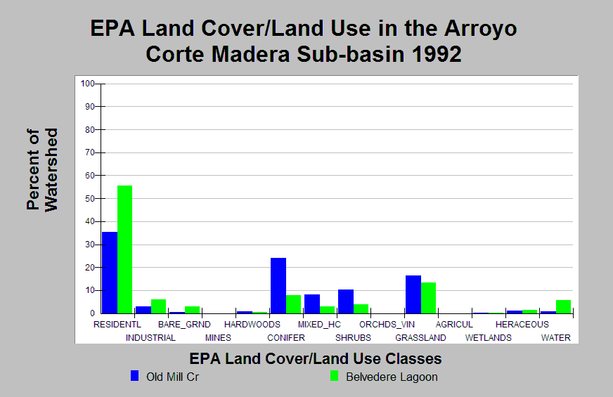
| Caption: This chart displays EPA Land Cover/Land Use data by Calwater Planning Watershed for the Arroyo Corte Madera sub-basin. Classes are derived from a 1992 Landsat image. The Arroyo Corte Madera sub-basin is highly urbanized, containing 56% and 36% residential area in Belvedere Lagoon and Old Mill Creek, respectively. The Calwaters contain 3-6% industrial area. Belvedere Lagoon contains 3% bare ground and 6% water area. Conifers and grasslands are prevalent in upland areas of Old Mill Creek (16-24%) and are also present in Belvedere Lagoon (8-13%). Mixed hardwood/conifer and shrubs show small coverage in both Calwaters. Click on the Map tab to view the EPA Land Cover/Land Use GIS layer. Click on Info Links for more information. | |
 |
To learn more about this topic click Info Links .
To view additional information (data source, aquisition date etc.) about this page, click Metadata .
To view the table with the chart's data, click Chart Table web page.
To download the table with the chart's data, click epa_landcover_calwaters.dbf (size 4,370 bytes)
To download the table with the chart's data as an Excel spreadsheet, click epa_landcover_calwaters.dbf.xls (size 10,671 bytes) .
| www.krisweb.com |