
| Area | Novato and Miller Creeks |
| Topic | Land Cover: EPA Land-Use, Novato and Miller Creeks Sub-basin 1992 |
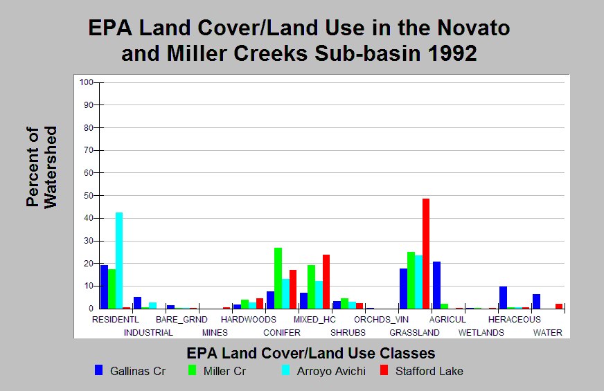
| Caption: This chart displays EPA Land Cover/Land Use data by Calwater Planning Watershed for the Novato and Miller creeks sub-basin. Classes are derived from a 1992 Landsat image. Arroyo Avichi, Gallinas Creek, and Miller Creek are 42%, 19%, and 17% residential area. Stafford Lake is only 0.5% residential area. Grassland areas cover 17-49% of the Calwaters. Conifer and mixed hardwood/conifer areas cover 7-27%. Click on the Map tab to view the EPA Land Cover/Land Use GIS layer. Click on Info Links for more information. | |
 |
To learn more about this topic click Info Links .
To view additional information (data source, aquisition date etc.) about this page, click Metadata .
To view the table with the chart's data, click Chart Table web page.
To download the table with the chart's data, click epa_landcover_calwaters.dbf (size 4,370 bytes)
To download the table with the chart's data as an Excel spreadsheet, click epa_landcover_calwaters.dbf.xls (size 10,671 bytes) .
| www.krisweb.com |