
| Area | North Fork Big River |
| Topic | Sediment: Matthews Landslides Volumes by Land-Use NF Big 1921-2000 |
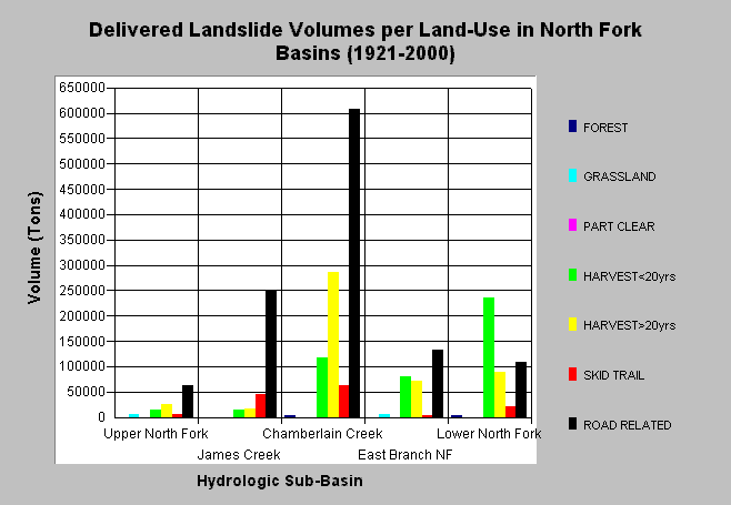
| Caption: The chart above shows the total estimated sediment volumes from delivered landslides by land-use practice in each North Fork Big River sub-basin (1921-2000). Sediment volumes were computed by Matthews and Associates (2001). Roads and harvest related slides contributed a majority of the sediment; specifically, road related slides have been important sediment contributors in James and Chamberlain Creeks. Matthews and Associates state: "Significant construction of new roads has led to increasing sediment yields from road surface erosion, despite improved practices. Under current conditions (1989-1999 period), management-related sediment delivery is estimated to be 51.7% of the total input." See Info Links for more background information and links to references. | |
 |
To learn more about this topic click here .
To view the table with the chart's data, click Chart Table web page.
To download the table with the chart's data, click slides_vol_ton_landuse_nf.dbf (size 1,075 bytes) .
To see meta information about the data table used for this topic click here
To view the table with the chart's source data, click Source Table web page.
To download the table with the chart's source data, click slides_vol_tons_landuse.dbf (size 2,712 bytes)
| www.krisweb.com |