Bibliography Background About KRIS
Hypothesis #4: Wood removal projects and logging in the riparian zone of the Garcia River and its tributaries have reduced large wood recruitment and aquatic habitat complexity, thus limiting coho salmon production.
Regional Support for the Hypothesis
Large wood is an extremely important element in helping create and maintain fish habitat diversity, especially in coastal streams (see Big Wood Background page). Among many fish habitat creating and maintaining roles, large wood ameliorates excess sediment supply (Kelley et al., 1995), and may also help keep streams cool by forcing more flow into shallow ground water (Poole and Berman, 2000). The function of large wood apparently most fundamental for coho salmon, however, is pool formation associated with bed scour. Large wood in streams has been shown to increase pool frequency and coho salmon production (Cedarholm et al., 1997).
Logging is recognized as a factor in decreasing wood supply to streams. Reeves et al. (1993) stated that streams on the Oregon coast with less than 25% of their watershed area previously logged "had significantly more pieces of wood per 100 meters, 2 to 12 times more, than streams in high-harvest basins. Streams in low-harvest basins also had 10-47% more pools per 100 meter than did streams in high-harvest basins". Reeves et al. (1993) also noted a loss of Pacific salmon species diversity in streams flowing from high harvest basins and traced it to aquatic habitat simplification. O'Connor (2000) noted that: "where riparian stands have been clear cut, it is likely that local recruitment of LWD will be severely reduced for several decades." Keithley (1999) used a cut off size of 24 inch basal diameter or larger to represent mid-late seral conifers which could function properly as large woody debris if recruited to a stream.
Holman and Evans (1964) documented the beginning of a wave of log jam removal from Mendocino coastal streams that focused on improving fish passage. Stillwater Sciences (1997) postulated that extraction of large wood had a major negative effect on coho salmon.
Garcia-Specific Support for the Hypothesis
The logging history of the Garcia dates back to late 1800's when the river was used as a transport corridor for logs. This would have lead to the first wave of streamside logging and the first change in large wood availability to the stream (Figure 1). Logging after World War II was equally destructive to Garcia River stream channels, but more widely distributed due to the availability of tractors and logging trucks. Logging and skidding often took place in stream channels (Figure 2) with long lasting effects on large wood supply. Destruction of tributary channels was so widespread that California Department of Fish and Game reports, like the one for the one for Signal Creek (CDFG, 1968) had only cryptic notes: "Stream side cover was destroyed by heavy logging". CDFG (1966) surveyed the logging damage to streams in the Garcia River basin and found that many riparian zones had been destroyed, particularly in the 37 miles of "severely damaged" stream reaches surveyed (Figure 3).
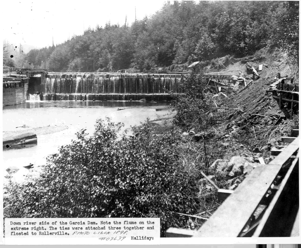 Figure 1. This picture shows the downriver side of the Garcia River Mill Dam, which was located upstream of the North Fork. Note that trees on the hillslope above the mill pond are early seral stage as a result of logging. The flume on the extreme right was used to float ties to downstream to Rollerville from where they were loaded on schooners offshore. Photo provided courtesy of the Held-Poage Memorial Home, Ukiah, California, and Robert Lee. Photo circa 1898. #03639 Halliday.
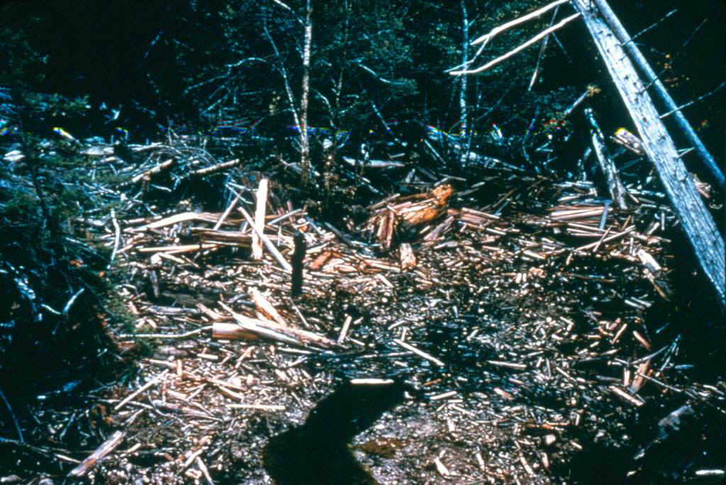 Figure 2. A California Department of Fish and Game Warden stands in the middle of a huge amount of slash which buries a stream somewhere in the Garcia River basin. The caption on the slide read: "Garcia River, stream debris, 11/3/54." This intensive logging in riparian zones not only had huge immediate consequences in terms of sediment yield, but also a long term impact on large wood supply to the Garcia River and its tributaries. Photo from CDFG, Yountville, CA.
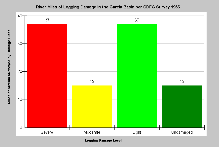 Figure 3. This chart shows the degree of damage to streams resulting from logging operations in the Garcia basin, according to a 1966 California Department of Fish and Game survey. The damage classes are severe, moderate, light and undamaged. The severe damage class was defined as areas where "streamside canopy and pools were totally eliminated." Data from CDFG (1966).
As post WW II logging sometimes loaded Garcia River stream channels with log butts, cull logs, and slash, CDFG (1968) began to routinely recommend stream clearance projects to re-establish fish passage. Numerous CDFG reports (1982a, 1982b, 1982c, 1985) document wood removal from Garcia River tributaries. Figure 4 shows a typical log jam removal project. These activities continued into the 1980's in the Garcia River basin and nearby tributaries such as Schooner Gulch.
![]() Figure 4. This photo shows a partially removed log jam on Blue Waterhole Creek. It is likely that stacks of wood, such as the one on the right bank in the photo, were moved to above flood height or burned. This loss of large wood reduced the ability of this creek to sort sediment and to provide complex fish habitat. More large wood spanning the channel of Blue Waterhole Creek might also help locally with water temperature problems by promoting more contact with the hyporheic zone. Currently, log jam barriers are modified to slowly release the sediment trapped above them and no large wood is removed from streams. Photo from the E-Center in Ukiah, CA.
Figure 4. This photo shows a partially removed log jam on Blue Waterhole Creek. It is likely that stacks of wood, such as the one on the right bank in the photo, were moved to above flood height or burned. This loss of large wood reduced the ability of this creek to sort sediment and to provide complex fish habitat. More large wood spanning the channel of Blue Waterhole Creek might also help locally with water temperature problems by promoting more contact with the hyporheic zone. Currently, log jam barriers are modified to slowly release the sediment trapped above them and no large wood is removed from streams. Photo from the E-Center in Ukiah, CA.
O'Connor (2000) found that levels of large wood in Garcia River tributaries were very low (Figure 5), when compared to regional streams in old growth forests or even to streams in second growth forests (Maahs and Barber, 20001). Mangelsdorf (1997) also noted that many tributaries of the Garcia River had low levels of large wood in their stream channels, which was limiting salmonid production. CDFG has called for the addition of large wood to the lower South Fork Garcia River (CDFG, 2003c) and its tributaries the Little South Fork (CDFG, 2003b) and Flemming Creek (CDFG, 2003a). These efforts at restoration are needed to offset past log jam removal projects and depletion, through logging, of the natural supply of large wood.
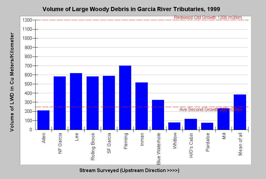 Figure 5. This chart shows the volume of large woody debris in cubic meters per kilometer in 12 Garcia River tributaries surveyed during the spring of 1999. Maahs and Barber (2001) note that other surveys on the north coast have shown that streams in old growth and second growth forests average 1200 and 220 cubic meter of LWD per kilometer, respectively. Most of the Garcia River streams shown in this graph exceed the 220 cubic meters of LWD per kilometer, but are well below the 1200 cubic meter old growth reference. Several were very low even for second growth forests. Data were collected by O'Connor Environmental (2000).
According to the California Department of Forestry records, timber harvest has remained active in the Garcia River basin since 1987, including some harvest in riparian zones in streams like Inman Creek (Figure 6). While these stream side areas may not be clear cut, as in prior eras, removal of some large trees has continued, which further reduces the potential large wood supply to streams.
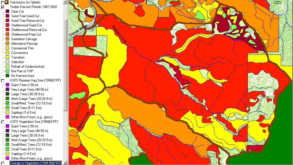 Figure 6. This map from the KRIS Garcia database shows timber harvests from 1987 to 2002 in the Inman Creek subbasin. Note that timber harvests were filed for most of the riparian zones of Inman Creek, although most harvests were not clear cuts. The recent harvests follow a previous wave of logging and further deplete an already reduced natural recruitment rate for large wood to Inman Creek. Data from CDF, Santa Rosa, CA.
The U.S. Forest Service Spatial Analysis Lab in Sacramento has provided Landsat imagery of vegetation for the Garcia River basin and all of California which can be used to characterize forest stand conditions (Warbington et al., 1998), including those in riparian zones. While stand conditions are calculated on a hectare basis and individual large diameter trees may be missed, this tool can be used to roughly estimate large wood supply (Keithley, 1999). A map of the riparian zone of Inman Creek is displayed below (Figure 7). Llarge wood recruitment to this stream is likely to be low for the next several decades. See the Vegetation Types Background page for more information on use of remote sensing vegetation imagery.
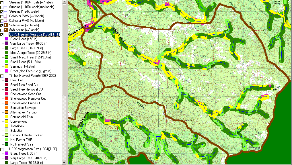 Figure 7. This map shows the size classes of trees of the Inman Creek riparian zone (90 M) according to 1994 Landsat imagery. Extensive reaches have trees averaging less than five inches in diameter (yellow). Conifers must be over 24 inches in diameter to provide lasting structural elements of aquatic habitat and there are only patches of Medium/Large (20"-30" diameter) and Large (30"-40" diameter) trees and none with average diameters over 40 inches. This represents a low supply of large wood for recruitment to the stream and also reflects recent logging. Data from USFS Spatial Analysis Lab, Sacramento, CA.
The following is a list of Topics in KRIS Garcia where you can see data in its context, Metadata and associated Info Links. The large-case letters in parentheses indicate KRIS sub-basins.
(BW) Tour: 2. Garcia River Historical Photos, Logging, Mill, Dam
(BW) Tour: 4. Garcia River Historical Photos, 1955 and 1962 Logging
(BW) Logging Damage: CDFG Garcia River 1966 Assessment
(BL) Tour: #1 Blue Waterhole Log Jam Removal
(BW) Wood: Large Woody Debris Volumes in Garcia R. Watershed, 1999
(IC) Map: 1F Timber Harvest 1987-2002, Inman Creek Sub-basin
(IC) Land Cover: USFS Veg Size in Riparian for Inman Creek 1994
Alternate Hypothesis
Large wood supply is not an appreciable factor in the decline of coho salmon abundance.
This alternative hypothesis points to the other factors which may reduce coho salmon abundance. Sedimentation could be the dominant limiting factor and large wood could not compensate for reduced pool volumes resulting from aggradation. High water temperature could also be a competing mechanism for coho decline. Ultimately, support for this alternative hypothesis must come from demonstration that coho salmon can persist in abundance in a variety of natural streams without large wood.
Monitoring Trends to Test the Hypotheses
Studies could be conducted wherein large wood could be added to streams with low numbers of coho to see if juvenile carrying capacity might be increased. Collecting additional data on coho salmon populations and aquatic habitat could answer questions about the relationship between large wood, pool habitat, and coho salmon persistence or decline.
References
California Department of Fish and Game (CDFG) . 1966. Stream damage surveys -- 1966. Written by L. Fisk, E. Gerstung, R. Hansen, and J. Thomas. Inland Fisheries Branch, CDFG. 15 pp. [162kb]**
California Department of Fish and Game (CDFG). 1968. Signal Creek (tributary to Garcia River) stream survey, 21 August 1967. Written by G. Holman. CDFG file memo . Yountville, CA . 3 pp. [56kb]**
California Department of Fish and Game (CDFG). 1982. Blue Water Hole Creek (Garcia River tributary) fish habitat improvement completion form. Unpublished CDFG memo. Yountville, CA. 1 p. [8kb]**
California Department of Fish and Game (CDFG). 1982. Schooner Gulch (Pacific Ocean tributary) fish habitat improvement completion form, 1March 1982. Unpublished CDFG file memo. Yountville, CA. 3 pp. [270kb]**
California Department of Fish and Game (CDFG). 1982. Signal Creek (Garcia River tributary) fish habitat improvement completion form. Unpublished CDFG memo. Unpublished CDFG file memo. Yountville, CA. 1 p. [4kb]**
California Department of Fish and Game (CDFG). 1985. North Fork Schooner Gulch (Pacific Ocean tributary) fish habitat improvement completion form, 13 December 1985. Unpublished CDFG file memo. Yountville, CA. 2 pp. [58kb]**
California Department of Fish and Game (CDFG). 2003a. Stream inventory report: Fleming Creek, South Fork Garcia River, 2002. CDFG, Central Coast Region. 25 pp. [1.4Mb]
California Department of Fish and Game (CDFG). 2003b. Stream inventory report: Little South Fork Garcia River, South Fork Garcia River, 2002. CDFG, Central Coast Region. 25 pp. [1.4Mb]
California Department of Fish and Game (CDFG). 2003c. Stream inventory report: South Fork Garcia River, Garcia River, 2002. CDFG, Central Coast Region. 26 pp. [1.5Mb]
Holman, G. and W. Evans. 1964. Noyo River Stream Clearance Projects. California Department of Fish and Game. 12 p.
Keithley, C. 1999. Evaluating stream and watershed conditions in Northern California. Prepared for the California Department of Forestry, Fire and Resource Assessment Program. Sacramento, CA . 17 pp. [1.06Mb]**
Kelly, E.A., A. MacDonald, T. Tally and N.J. Merrit. 1995. Effects of Large Organic Debris on Channel Morphology and Sediment Storage in Selected Tributaries of Redwood Creek, Northwestern, California. U.S. Geologic Survey Professional Paper 1454-P, Menlo Park, CA. 29 p.
Maahs, M. and T. J. Barber. 2001. The Garcia River instream monitoring project. Final report to California Department of Forestry and Fire Protection. Mendocino County Resources Conservation District. Ukiah, CA. 104 pp. [750kb]
Mangelsdorf, A. editor.1997. Assessment of aquatic conditions in the Garcia River watershed. Prepared in support of the Garcia River watershed water quality attainment strategy for sediment. California Regional Water Quality Control Board, North Coast Region. Santa Rosa, CA. 283 pp.
O'Connor Environmental, I. 2000. Garcia River large woody debris instream monitoring. Mendocino County Resources Conservation District. Healdsburg, CA. 23 pp. [100kb]
Poole, G.C., and C.H. Berman. 2000. Pathways of human influence on water temperature dynamics in stream channels. Environmental Management. 20 pp.
Reeves, G.H., F.H. Everest and J.R. Sedell. 1993 . Diversity of Juvenile Anadromous Salmonid Assemblages in Coastal Oregon Basins with Different Levels of Timber Harvest. Transactions of the American Fisheries Society. Vol 122, No. 3. May 1993.
Stillwater Sciences. 1997. A review of coho salmon life history to assess potentially limiting factors and the implications of historical removal of large woody debris in coastal Mendocino County. Prepared by Stillwater Sciences, Berkeley CA for Louisiana-Pacific Corporation, Wildlife and Fisheries Science Group, Forest Resources & Fiber Procurement Division. May 1997. 55 pp.
Warbington, R., B. Schwind, C. Curlis and S. Daniel. 1998. Creating a Consistent and Standardized Vegetation Database for Northwest Forest Plan Monitoring in California. USDA Forest Service. Pacific Southwest Region Remote Sensing Lab. Sacramento, CA.