
| Area | Arcata |
| Topic | Roads: Densities in Arcata Sub-Basins 2000 |
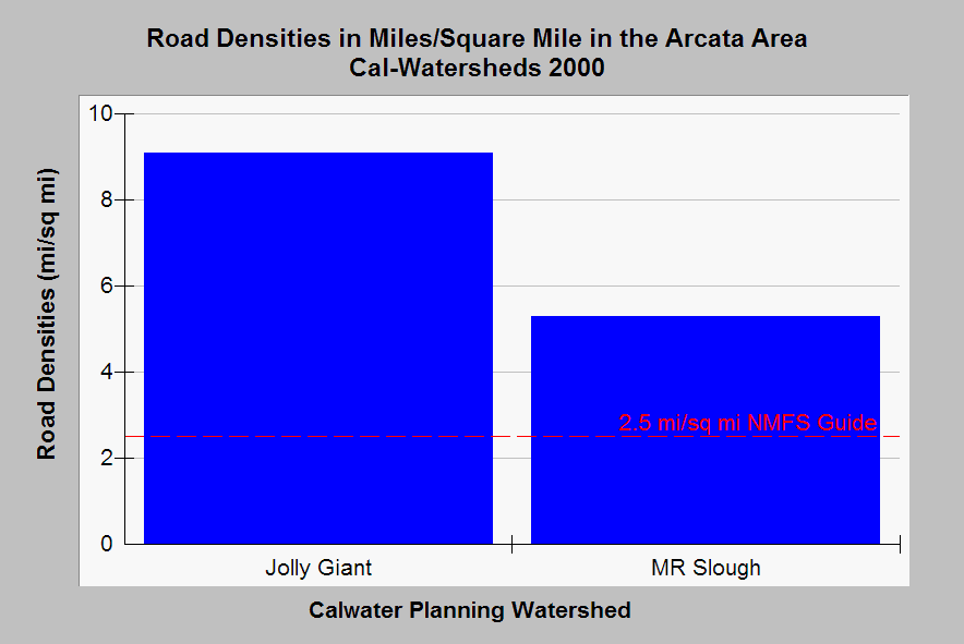
| Caption: This chart shows the road density within the Arcata portion of Humboldt Bay Calwater Planning Watersheds as miles of road per square mile of watershed. The most urbanized watershed, Jolly Giant, ranks highest while the Samoa are of Humboldt Bay has few roads because it covers the pasture land extending back towards Arcata. Few roads in these Calwaters are associated with timber harvest but are instead from urbanization surrounding Arcata. The Mad River (MR) Slough is less urbanized than Jolly Giant but still has a road density of 5.1 mi./sq.mi. Proper watershed function for salmonid habitat according to National Marine Fisheries Service (1996) is 2.5 miles per square mile, which is shown as a reference above. Data from Legacy the Landscape Connection with summary statistics generated by the Institute for Fisheries Resources. See Info Links for access to more background information. | |
 |
To learn more about this topic click Info Links .
To view additional information (data source, aquisition date etc.) about this page, click Metadata .
To view the table with the chart's data, click Chart Table web page.
To download the table with the chart's data, click roads_ar_2000.dbf (size 2,871 bytes)
To download the table with the chart's data as an Excel spreadsheet, click roads_ar_2000.dbf.xls (size 3,584 bytes) .
| www.krisweb.com |