
| Area | S.F. Trinity |
| Topic | Temperature: Floating Weekly Maximum Hayfork @ NRCS Sites 01-04 1997 |
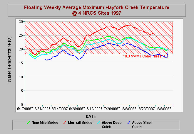
| Caption: The Chart above shows the floating weekly average of Hayfork Creek at four locations for 1997. Water temperatures at Mercill Bridge at the bottom of Hayfork Valley were acutely stressful or lethal for salmonids in August 1997. Hayfork Creek is coolest above Shiell Gulch (below Wildwood), warms below Deep Gulch (above Hayfork Valley). Hayfork Creek at Nine Mile Bridge moderates in temperature because of the cooling influence of Rusch and Little Creeks as well as smaller tributaries. Temperatures at Mercill Bridge are certainly elevated by flow depletion and riparian conditions in Hayfork Valley and tributaries such as Salt Creek and Carr Creek. The maximum weekly maximum temperature (MWMT) threshold (18.3 C) for suitability for coho salmon comes from Welsh et al. (2001). See Picture for a map of gauge locations. | |
 |
To learn more about this topic click Info Links .
To view additional information (data source, aquisition date etc.) about this page, click Metadata .
To view the table with the chart's data, click Chart Table web page.
To download the table with the chart's data, click haymax97.dbf (size 18,529 bytes) .
To view the table with the chart's source data, click Source Table web page.
To download the table with the chart's source data, click hf_temps.dbf (size 4,579,055 bytes)
| www.krisweb.com |