
| Area | Basinwide |
| Topic | Sediment: Road-Related Potential Erosion in Navarro Watershed, Volume |
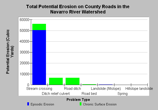
| Caption: This charts shows total potential erosion related to 72.6 miles of Mendocino County roads in the Navarro River watershed that were surveyed in the years 2000 and 2001 as part of the Five Counties Road Erosion Inventory with potential for yield of over 60,000 cubic yards of sediment. Chronic surface erosion includes more gradual processes, like a ditch down cutting, and is estimated here over a 10-year period. Stream crossing failures clearly present the greatest risk of episodic, catastrophic erosion potential. Data were collected by the Mendocino County Department of Transportation, with training and protocol design by Pacific Watershed Associates. Data were provided to KRIS by the Trinity County Planning Department. See Info Links for more information. | |
 |
To learn more about this topic click Info Links .
To view additional information (data source, aquisition date etc.) about this page, click Metadata .
To view the table with the chart's data, click Chart Table web page.
To download the table with the chart's data, click sediment_road_nav_fcrei_00_01.dbf (size 971 bytes) .
| www.krisweb.com |