Bibliography Background About KRIS
Hypothesis #4: Elevated water temperatures in Gualala River tributaries limit coho salmon and steelhead trout production.
Support for the Hypothesis
Two recent studies conducted in northern California found that coho salmon were at extremely low abundance or absent in streams where the floating weekly average water temperature (MWAT) exceeded 16.8o Celsius (62.3o F) one or more times during the season (Welsh et al., 2001; Hines and Ambrose, 1998). While steelhead are more tolerant of high water temperatures than coho, they too become sub-dominant to warm water species when stream temperatures are elevated (Reeves, 1985). Armor (1990) notes that all salmonids cease growth over 20o C. See the Temperature background page for information on these studies, temperature tolerances of salmon and trout, and the factors that effect stream temperature.
Gualala Redwoods Inc. (GRI) has monitored water temperatures of streams within its holdings with automated temperature sensing devices since 1992. The Gualala River Watershed Council also has collected data in recent years and their data is included in summaries below. The KRIS IFR staff received summary data, rather than raw data, from the North Coast Regional Water Quality Control Board (NCRWQCB). Floating weekly average water temperatures exceeded 16.8° C (62.30 F) in mainstem locations of all Gualala sub-basins measured (Figures 1-6). This indicates that temperature would be limiting to coho salmon production in these streams.
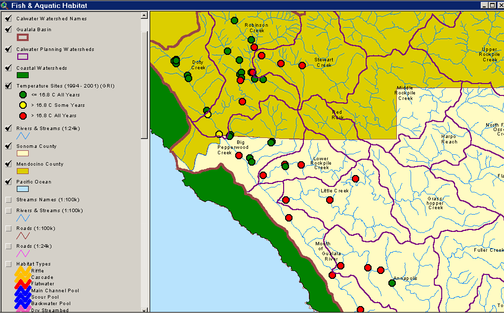 Figure 1. This image shows water temperature gauge locations and indicates suitability for coho in the western Gualala River basin. Green indicates that water temperatures were suitable for coho in all years (<16.8 C MWAT), red shows unsuitable temperatures in all years and yellow indicates that some years were suitable and others unsuitable. County boundaries and Calwater Planning Watersheds are shown for reference.
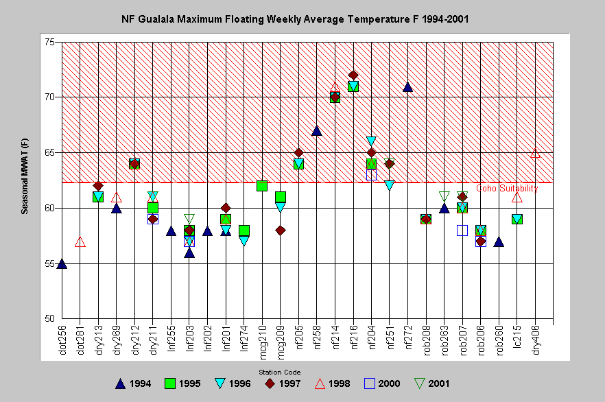 Figure 2. This chart shows the maximum floating weekly average water temperature at stations in the North Fork Gualala River and its tributaries. While Doty Creek (doty), Little North Fork Gualala (lnf), Robinson Creek (rob) and McGann Gulch (mcg) may have water temperatures that are not limiting salmonid production, the mainstem North Fork Gualala (nf) and the middle reach of Dry Creek (dry12) exceeded 62.3o Fahrenheit (=16.8o C) in all years measured (except at site nf251 in 1996). Mainstem North Fork had floating average temperatures over 68 o F (20o C), therefore, steelhead growth and production would be limited.
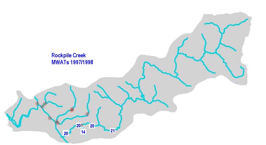
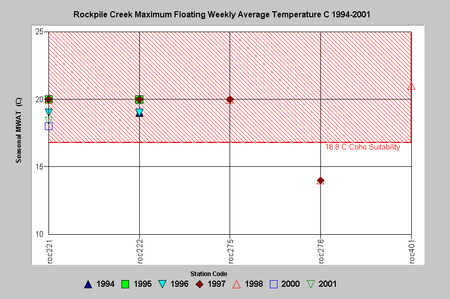 Figure 3. This chart shows the seasonal maximum of the floating weekly average water temperature (MWAT) in Celsius derived from automated temperature probes placed in Rockpile Creek. Water temperatures were low enough to support coho salmon (<16.8 C) in Little Creek (roc276), a second order tributary, but too warm to support them at any station in lower Rockpile Creek. The MWAT of 20o C at mainstem locations in Rockpile would also limit steelhead growth. See Map for a view of temperature station locations and MWAT in Celsius for lower Rockpile Creek.
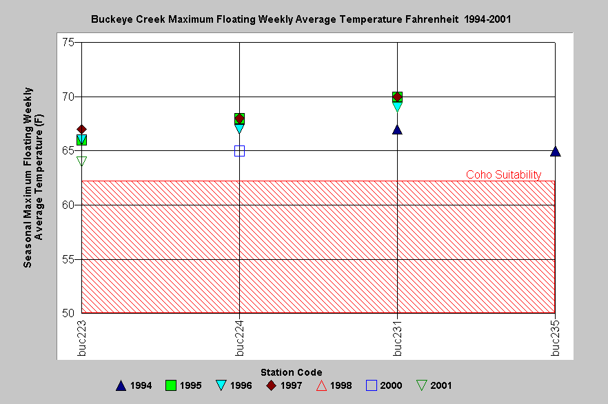 Figure 4. The Buckeye Creek seasonal maximum of the floating weekly average temperature (MWAT) for several years is displayed at left (in Fahrenheit). Data indicate that in all years measured, all Buckeye stations were over optimal temperatures for salmonid rearing and above the range known to support coho salmon juveniles .
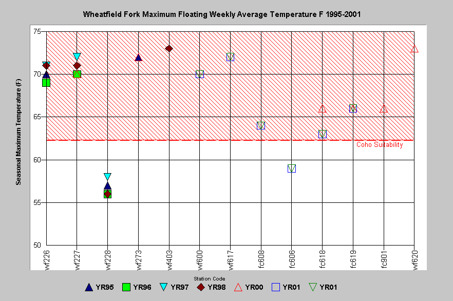 Figure 5. The seasonal maximum of the floating weekly average water temperature (MWAT) derived from automated temperature probes placed in the Wheatfield Fork Gualala River, including Fuller Creek (fc), is depicted at left. The data suggests that only the Fuller Creek station (fc606) and the Wheatfield station on a small tributary (wf228) could support rearing of coho salmon juveniles (62.30 F according to Welsh et al., 2001). The mainstem Wheatfield Fork temperatures are acutely stressful for steelhead as well.
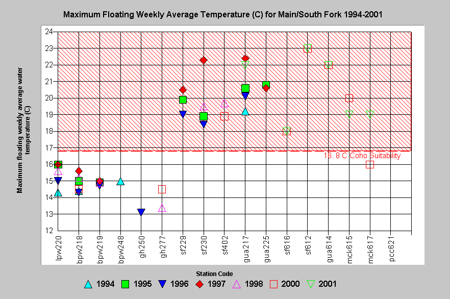 Figure 6. This chart shows the maximum floating weekly average water temperature (MWAT) of all the sites in the South Fork Gualala River and selected tributaries from 1994 to 2001. All Big Pepperwood Creek (pw) stations were not temperature limited with regard to coho salmon production. South Fork Gualala River (sf), mainstem Gualala (gua) and McKenzie Creek (mck) were moderately to highly impaired with regard to salmonid suitability.
Fish community structure charts provide corollary support for the hypothesis. Many mainstem reaches and warmer tributaries of the Gualala are dominated by the endemic Gualala roach, which can withstand water temperatures up to 950 F (Figure 7). The absence or low relative abundance of steelhead in these areas is an indicator of major temperature impairment of salmonid habitat. California Department of Fish and Game noted that coho salmon inhabited the lower North Fork Gualala River (Parker and Poole, 1964). Their absence today and their inability to re-establish themselves after hatchery coho planting from 1995 to 1997 is consistent with the hypothesis that high water temperature is limiting juvenile habitat suitability in the mainstem North Fork.
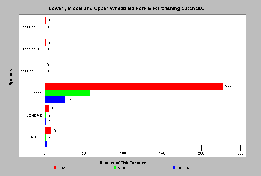 Figure 7. California Department of Fish and Game electrofishing in September 2001 showed that the lower, middle and upper mainstem Wheatfield Fork Gualala River had almost no steelhead. Instead Gualala roach dominated samples with stickleback and sculpin also present. The endemic roach is well adapted to warm water and thrives in reaches with elevated temperatures.
The following is a listing of topics and maps from the KRIS Gualala database and the KRIS Gualala Map project that are used in the arguments above. Viewing them in context allows access to data, Metadata and associated Info Links. The large-case letters in parentheses indicate KRIS Gualala sub-basins.
Fish and Aquatics View: KRIS Gualala Map project.
(NF) Temperature: Maximum Floating Weekly Average (C) NF Coho Ref 1994-2001
(RC) Temperature: MWAT Rockpile 1994-2001 w/ Coho Tolerance Reference
(BC) Temperature: MWAT (F) Buckeye Cr vs. Coho Stress Threshold 1994-2001
(WF) Temperature: MWAT (F) Wheatfield vs. Coho Threshold 1995-2001
(SF) Temperature: Yearly MWATs for Main/South Fork Vs Coho Reference
(WF) Fish: Lower/Mid/Upper Wheatfield Fork Gualala E-fishing, 2001 by CDFG
Alternative Hypothesis
Mainstem reaches of the Gualala River were always warm and coho were never predominant there.
Lewis et al. (2000) pointed out that lower-river temperatures are elevated as a result of being further from their spring sources and that water temperatures in interior basins were more subject to warming than those in the fog zone. Henry Alden of Gualala Redwoods, Inc. favors the alternative hypothesis that stream warming is largely a function of stream size. See a chart of his regression of watershed size and water temperatures from the May draft Gualala River Watershed Synthesis Report (California Resources Agency, In review).
Monitoring Trends to Support or Refute the Hypothesis
While the hypothesis offered has been supported by current field data in the Gualala basin, relationships of salmonid abundance and distribution could be further explored if conditions change. For example, if sediment control is implemented and riparian zones allowed to mature, canopy and improved width to depth ratio should result in decreased water temperature. Monitoring fish community structure and salmonid abundance to see how they respond to decreasing water temperatures would provide a means to test this hypothesis.
References
Armour, C.L. 1991. Guidance for evaluating and recommending temperature regimes to protect fish. U.S. Fish and Wildlife Service. Fort Collins. Biological Report 90(22). 13 p.
California Resources Agency. In Review. Gualala River Watershed Synthesis. CA Dept. of Fish and Game, State Water Res. Control Bd., CA Dept. of Water Resources, CA Div. on Mines and Geology and CA Dept. of Forestry. Sacramento, CA. Draft released January 16, 2001.
Hines, D.H. and J.M. Ambrose. 1998. Evaluation of Stream Temperature Thresholds Based on Coho Salmon (Oncorhynchus kisutch) Presence and Absence in Managed Forest Lands in Coastal Mendocino County, California. Georgia Pacific Corporation, Ft. Bragg, CA. 14 p plus Appendices.
Lewis, T.E. , D.W. Lamphear, D.R. McCanne, A.S. Webb, J.P. Krieter, and W.D. Conroy. 2000. Executive Summary to Regional Assessment of Stream Temperatures Across Northern California and Their Relationship to Various Landscape-Level and Site-Specific Attributes. Forest Science Project, Humboldt State University Foundation, Arcata, CA.
Parker, C. and R.L. Pool. 1964. North Fork Gualala River Stream Survey, North Fork Gualala River surveyed by foot and automobile from the mouth to the headwaters, a total of 15 miles. September 17-18, 1964. California Department of Fish and Game, Region 3, Yountville, CA. 2 p.
Reeves, G.H. 1985. Competition between redside shiners and steelhead trout in the Umpqua River, Oregon. Doctoral thesis, Oregon State University, Corvalis, Ore.
Welsh, H.H., G.R. Hodgson, M.F. Roche, B.C. Harvey. (2001). Distribution of Juvenile Coho Salmon (Oncorhynchus kisutch) in Relation to Water Temperature in Tributaries of a Northern California Watershed: Determining Management Thresholds for an Impaired Cold-water Adapted Fauna. North American Journal of Fisheries Management, 21:464-470, 2001.