Bibliography Background About KRIS
Kootenai River Sediment Discharge and Road Decommissioning Data
The sediment data example for the pilot KRIS Kootenai project were provided by the Idaho Panhandle National Forest (IPNF) of the U.S. Department of Agriculture Forest Service, Northern Region. The IPNF falls partially within the Kootenai River basin. The IPNF Forest Plan was accepted in September of 1987 and contains protocols for monitoring and evaluation to enable adaptive management. Annual monitoring reports are published by IPNF (USFS, 1998; 1999; 2000a; 2001).
Water quality monitoring is part of the Forest Plan Monitoring and Evaluation Report and includes sediment transport as a parameter to evaluate the impacts of forest management. Suspended sediment loads, bedload, and stream discharge have been monitored in many small disturbed and undisturbed watersheds within IPNF. Monitoring data extends back to 1974 and are used to calibrate and verify watershed response models, which are used to estimate annual suspended sediment load and bedload based on daily average discharge. Roads have been recognized as a major source of sediment on the Forest and data are included in the pilot KRIS Kootenai project on road decommissioning from the annual report (USFS, 2000a).
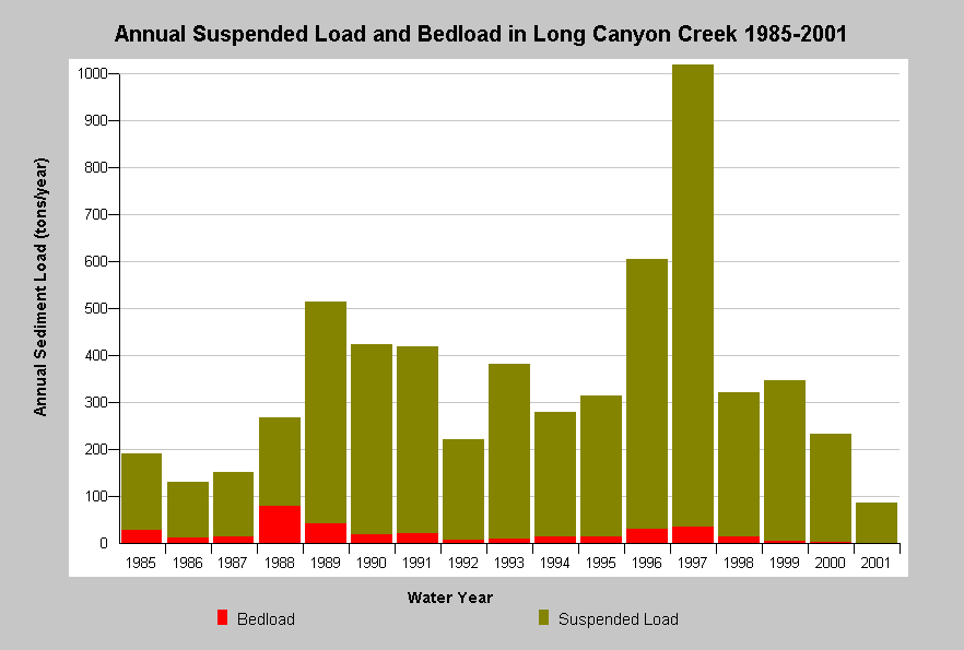 This chart shows the annual calculated suspended sediment load and bedload moving through the Long Canyon Creek system from 1985 through 2001. Sediment loads mainly consist of finer suspended sediments. Long Canyon Creek is a tributary to the Kootenai River in the Idaho Panhandle National Forest. Data are from the USDA Forest Service Northern Region, Idaho Panhandle National Forest.
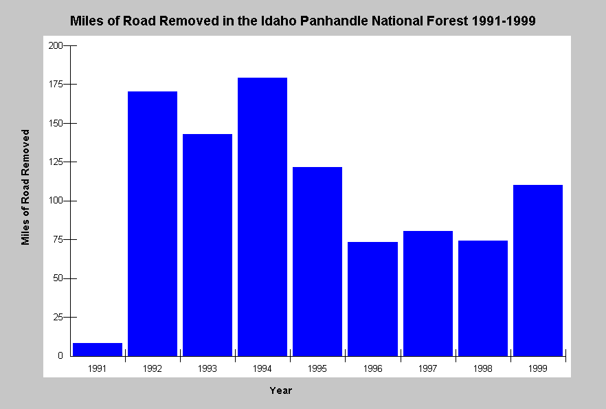 This chart shows the total miles of roads removed per year in the Idaho Panhandle National Forest. Road removal was at its highest in the early 1990's, but a substantial amount of erosion control work related to roads has continued in recent years. Roads and road failure are recognized as a major source of sediment to streams. Data come from the Forest Plan Monitoring and Evaluation Report (IPNF, 1999).
References
USDA, Forest Service (USFS). 1998. Forest plan monitoring and evaluation report - 1998. Idaho Panhandle National Forests. Coeur d'Alene, ID. 166 pp. [835k]
USDA, Forest Service (USFS). 1999. Forest plan monitoring and evaluation report - 1999. Idaho Panhandle National Forests. Coeur d'Alene, ID. 77 pp. [795k]
USDA, Forest Service (USFS). 2000a. Forest plan monitoring and evaluation report - 2000. Idaho Panhandle National Forests. Coeur d'Alene, ID. 80 pp. [1.5Mb]
USDA, Forest Service (USFS). 2000b. Forest assessment of major fires 2000. USFS, Kootenai National Forest. Libby, MT. 113 pp. (document body + appendices F and G.) [2.2Mb]
USDA, Forest Service (USFS). 2001. Forest plan monitoring and evaluation report - 2001. Idaho Panhandle National Forests. Coeur d'Alene, ID. 127 pp. [2.8Mb]