Bibliography Background About KRIS
Roads and Upland Sediment Sources in Maine DPS Atlantic Salmon Watersheds
The Atlantic Salmon Conservation Plan for Seven Maine Rivers (MASTF, 1997) identified sediment as a potentially limiting factor, sources of sediment and impacts:
"The proportion and distribution of different land uses within a watershed influence their cumulative effects on these habitat characteristics...... Sediment eroded from roads, cleared and developed land, agricultural fields and pastures, and poor forestry practices fills spaces in gravel streambeds, reducing productive capacity."
Several land uses are examined below with regard to sediment yield and cumulative effects on Atlantic salmon habitat. These include road systems and their maintenance, off-road vehicle use, timber harvest, and agricultural activities. Potential solutions to the problems these land uses sometimes pose are also discussed.
Roads
The National Research Council (2003) ranked roads second only to large dams as a the most significant impediment to Atlantic salmon recovery. The Council noted a shift from more intensive land use activities that cause catastrophic habitat disturbance to a more subtle but pervasive one: "Acute disturbance from log drives and the toxic effects of point source discharges have been replaced by the chronic effects of road networks." The NRC (2003) section on roads points out that problems they pose for salmon are more diverse than just sediment yield:
"With the exception of large dams on the lower reaches of rivers, no human alteration of the landscape has a greater, more ubiquitous impact on aquatic habitat than roads. Every road-stream crossing has the potential to be a barrier to fish passage and a major source of sediment. A well-designed road, either paved or unpaved, has a slight crown along the centerline to direct rain or snowmelt off to the sides. In some cases, stormwater flows harmlessly off into the adjacent forest or fields and is termed 'country drainage' by engineers. More often it is collected in ditches or swales that parallel the road, sometimes for long distances. As the volume and velocity of flow increases so does the quantity of sediment that can be transported. Clay, silt, and fine sand that accumulates in road ditches is the first to be transported to streams during rain and snowmelt events. Soil particles also carry nutrients, metals, and other potential nonpoint source (NPS) pollutants on their charged surfaces. In addition, fine sediment increases turbidity in streams. Unless deliberate efforts are made to divert or store water and sediment along the way, they flow unimpeded into streams at every road crossing."
Rieman et al. (2002) used road density as a proxy for cumulative watershed effects in Pacific northwest bull trout watersheds and found that population levels were inversely proportional to road densities. Haynes et al. (1996), in a regional study of public lands in the Columbia Basin, determined that bull trout were absent in watersheds with more than 1.5 miles of road per square mile of watershed area and that "the higher the road density, the lower the proportion of sub-watersheds that support strong populations of key salmonids." The National Marine Fisheries Service (NMFS, 1996) defined properly functioning aquatic conditions for Pacific salmon watersheds as having less than 2.5 miles per square mile, with no or few streamside roads. There is currently no recognized threshold for road density in Maine and accurate road maps for conducting road density calculations are not available for Atlantic salmon watersheds such as the Sheepscot River. NRC (2003) predicted that road networks are likely to expand as rural populations grow and development progresses in Maine DPS Atlantic salmon watersheds.
Surface Erosion: The harsh winter conditions in Maine require road maintenance measures such as salt or sand in order to be able to allow safe travel by automobile. Dill et al. (2002) noted problems related to winter treatment of roads to melt ice and snow. Salt washes into streams and occasionally pollutes ground water, whereas sand can chronically enter streams through ditches and at road crossings:
"Sand that remains on the roads after the end of the season is generally swept off the roadways onto the shoulders. Sometimes this sand is collected and disposed of as inert fill....... Sand that washes into streams and rivers can result in turbidity problems and habitat embeddedness. This is especially noticeable in the Sheepscot River because it has a higher road density and more stream crossings than the other salmon rivers."
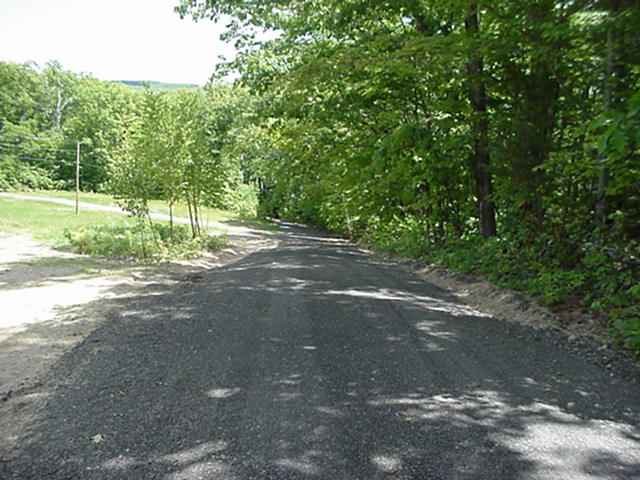
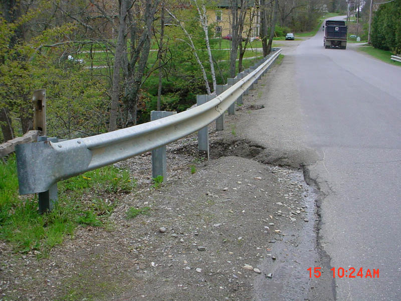 The constant supply of sediment to streams may not have perceptible impacts to an untrained observer but the consequences for salmon survival can be significant and include reduced survival in eggs hatching or fry emerging, decreased rearing space and food supply and diminished ability to feed because of turbidity (see Sediment and Atlantic Salmon Habitat page). The picture at left shows sand building up at a road crossing and washing down into the West Branch Sheepscot River as indicated by the gully between the third and fourth guard rails.
If un-surfaced or rocked roads get used during wet periods, it may increase sediment delivery by pumping fines from the road bed which then are contributed to adjacent streams. Dill et al. (2002) found that, although unsurfaced roads may get little use in winter, they are still "prone to non-point source (NPS) pollution due to erosion on the road surfaces, roadside ditches, or bank erosion at stream crossings."
Road-Stream Crossings: Road crossings are the most pervasive non-point source pollution sites in Maine Atlantic salmon DPS watersheds (Dill et al., 2002; Project SHARE database). Halsted (2002) explained that:
"Crossing structures that are undersized act as dams in the river, which cause the river to compensate by altering the natural channel. Often scours result upstream and downstream of the crossing. Undersized crossings can also create a buildup of sediment upstream causing unnatural braiding to occur."
Road crossings are often the place where sediment from road side ditches flows into streams. In worst case scenarios, culverts used to route streams under roads may plug and fail, washing sediment from the road prism into the water course below (NRC, 2003). The National Marine Fisheries Service and U.S. Fish and Wildlife Service (NMFS & USFWS, 2004) also express concern over significant problems for fish passage that culverts may pose:
"Other obstructions to passage, including poorly designed road crossings and culverts, remain a potential hindrance to salmon recovery. Improperly placed or designed culverts can create barriers to fish passage through hanging outfalls, increased water velocities or insufficient water velocity and quantity within the culvert."
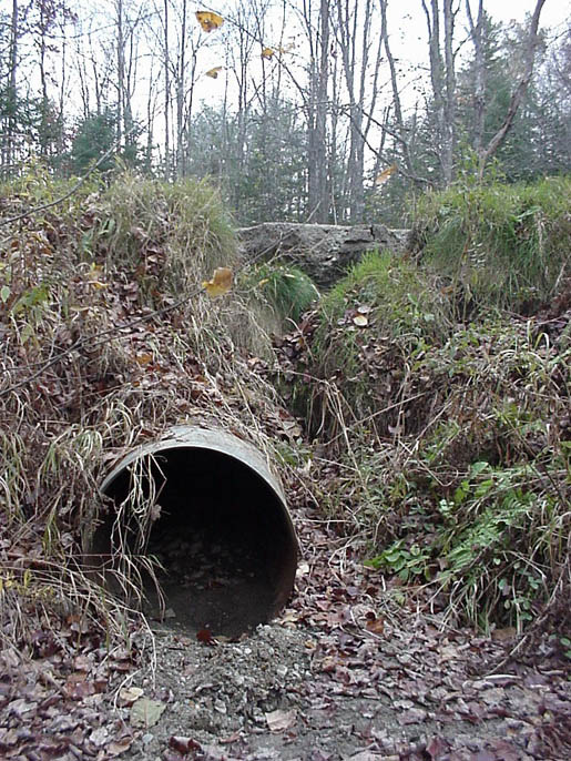
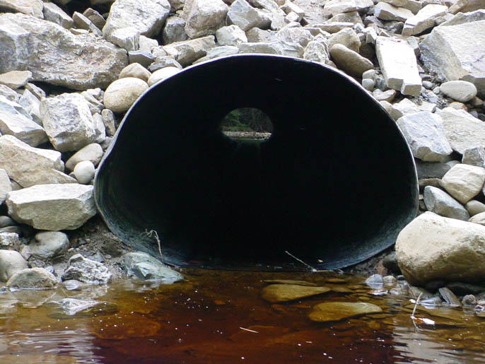
 The photo at right shows a culvert too steep to pass Atlantic salmon or other migratory fishes because of high velocities at high flow. Culverts only have an expected life of about 25 years and this one is failing where two pipes are joined at mid-way. Leaking culverts allow water into the road fill and can cause crossing failures.
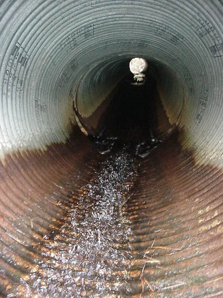
Looking upstream at a culvert outlet in the Sheepscot River watershed with major erosion problems (right photo). Water has spilled over the road surface causing a major gully, likely because the culvert was plugged with debris at its upstream end causing water to spill over the road prism. The soil missing from the gully was washed away during high flows and cycled through the lower Sheepscot River. Photos by Melissa Halsted.
Halsted (2002) pointed out that there were still active and abandoned railroad road beds in the Sheepscot River basin that could cause erosion problems at stream crossings and that surveys should take place at historic as well as actively used crossings.
Road Related Water Pollution from Herbicides: Since the 1960's, herbicides have been used to maintain road right of ways from encroaching vegetation (Dill et al., 2002). If roads parallel streams, there is an opportunity for the introduction of these substances into streams and they are known to have some potential negative effects on Atlantic salmon (see Water Pollutants page). No herbicides are now used for road maintenance in the Maine counties of Hancock and Washington because of concerns for the health of salmon rivers. Large industrial timber companies such as International Paper have stopped any spraying in riparian zones, including for road maintenance (Dill et al., 2002), although there are no State statutes prohibiting it.
All Terrain Vehicle (ATV) or Off Road Vehicle (ORV) Trails and Erosion
Old abandoned railroad right of ways, logging spur roads and skid trails may used by recreational ATVs and ORVs, which prevents or retards their revegetation and can contribute sediment to water courses. Off road vehicles driving through streams cause direct harm, but ruts from tire tracks form gullies that continue to widen and deepen from the erosive force of water during subsequent storms or spring run off.
 The NRC (2003) noted that education is needed for ATV and ORV users:
"ATVs ("quads" or "four-wheelers") and ORVs (four-wheel drive trucks and sport-utility vehicles) can cause substantial damage to soils, water, and aquatic ecosystems unless their use is carefully planned and managed. Whenever people re-enact television commercials by fording streams, climbing steep banks or hills, and mixing, rutting, and compacting soil they cause a host of environmental impacts. This damage may be inadvertent or intentional, but in either case their actions can negate months or years of work to control NPS pollution in one Saturday afternoon" (NRC, 2003).
This photo shows an ATV trail in the Sheepscot River basin that is in a low, wet area and appears to have at least partially diverted or captured a local stream.
Timber Harvest
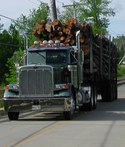
The NRC (2003) points out that 7.3 million acres of Maine's 17.7 million acres of forest are owned by forest products companies and that "during the 1990s, timber harvesting increased from about 400,000 to more than 500,000 acres per year." This increase, however, may be in part due to a shift away from clear cutting and toward selective logging (MFS, 1998; 2002). Timber harvest is a minor issue in some Maine Atlantic salmon DPS rivers, such as the Sheepscot and Duck Trap, but is a major land use in some Downeast watersheds such as the Machias and Narraguagus rivers.
- Erosion caused by forestry activities is most likely to occur in association with skid trails and haul roads in steep terrain and when soils are saturated, because of the combined potential for soil disturbance and for overland flow,
- The major causes of erosion problems in New England are improperly designed landings and truck roads,
- Many of the erosion problems with roads and skid trails originate at the point of intersection with running water,
- The closer the proximity of heavy equipment operation to streams, the greater the potential for persistent sedimentation problems, and
- The removal of a large volume of trees (which generates greater skid and haul traffic) was associated with an increased likelihood of erosion.
The Maine Atlantic Salmon Commission (1997) stated that most sediment pollution related to logging could be controlled by adherence to best management practices (BMPs), which are measures designed to minimize soil displacement and transport. The Maine Department of Conservation and the Maine Department of Forestry define BMPs for forestry related activities (MDC, 2004). The Maine Department of Environmental Protection (1994, as cited in Stafford et al., 1996) found that 30% of timber harvests reviewed for potential NPS exhibited serious potential for erosion and had not followed BMP procedures.
The NRC (2003) expressed concern that the combination of forest harvest and associated road networks had the potential to change flow as well as water quality. Jones and Grant (1996) found that forest harvest in combination with roads caused significant increases in storm peaks in the Cascade Range in Oregon. While application of BMPs may lessen changes in sediment yield and flow regimes, there may still be potential for cumulative watershed effects, if too great an area is disturbed in too short a period of time (Dunne et al., 2001). The Maine Forest Practices Act (MDC, 2004) reflects concern over widespread depletion of forest resources, particularly if forest land is sold immediately after clear cutting:
"Liquidation harvesting is a serious and direct threat to forest management, forest industries and rural communities over the landscape of Maine. Liquidation harvesting produces significant adverse economic and environmental effects and threatens the health, safety and general welfare of the citizens of the State. Liquidation harvesting is incompatible with responsible forest stewardship and must be substantially eliminated."
The National Marine Fisheries Service and U.S. Environmental Protection Agency (NMFS & EPA, 2003) have signed an MOU with the State of Maine pursuant to Atlantic salmon recovery stating that current statutes provide authority to control adverse effects from forestry, including updating of BMPs (see Solutions section below).
Agriculture
Historic information suggest that watershed disturbance in Maine related to agricultural has decreased dramatically and that much of the land formerly in active farms has reverted to forests (Irland, 1998). While Bryant and Mahoney (1950) found some active erosion related to farming, they found more stream side areas in recovery with deciduous trees colonizing banks of fallowed lands. More recent Sheepscot surveys (SRWC, 2002) find only isolated cases of pollution related to agricultural activities. Downeast rivers have large scale blue berry farms and pollution related to agriculture is more of a concern in those basins. Dill et al. (2002) note that agricultural fields can still be a source of sediment in Atlantic salmon rivers, but in "surveys of the non-point source pollution sources in the watersheds of the Narraguagus and Pleasant Rivers, almost all of the sources have been land management roads and road crossings rather than direct erosion from fields" (Project SHARE NPS database).
The NMFS and U.S. EPA (2003) found existing law and management authority were available for the State of Maine to adequately protect Atlantic salmon and water quality.
Remedying Road-Related Problems and Non-Point Source Pollution in Maine DPS Atlantic Salmon Rivers
Solving problems related to NPS on Maine Atlantic salmon rivers calls for problem identification, project prioritization, and coordination with land owners, responsible agencies and nearby communities (KSWCD, 2003).
 The Kennebec Soil and Water Conservation District (2003) performed an inventory of road related erosion problems by surveying both from roads and from the stream bed of the West Branch Sheepscot River and its tributaries. Many sites with active erosion were identified and land owners or MDOT or town road commissioners notified. Much work has been done to remedy problems (see below).
The NRC (2003) provided advice for avoiding road related NPS:
-
Careful route planning to keep roads on resistant terrain and minimize the number of road-stream crossings,
-
Bridge and culvert designs with hydraulic characteristics that permit fish passage in both directions for different life stages,
-
Bioengineering techniques to stabilize embankments (either cut or fill slopes) associated with road construction,
-
Stormwater management practices to eliminate or reduce the hydraulic connections between roads and streams,
-
Aggressive soil erosion control on new construction or unstable areas, and
-
Regular preventive maintenance to prevent debris dams or beaver from blocking culverts.
NRC (2003) points out that maintenance at road crossings and culverts can prevent plugging and crossing failure, which is the worst possible scenario for sediment yield.
 This is a West Branch Sheepscot River tributary passing through a newly installed flat-bottomed culvert on Reed Road in the Town of Windsor. This culvert has greater capacity for flood flow than the one it replaced and is, therefore, less likely to fail during storms. It is installed flush with the stream bottom and at a proper grade for fish passage. This is a 319 H funded project by the Kennebec Soil and Water Conservation District (KSWCD, 2003).
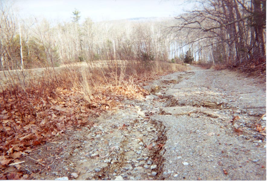
 The photo at left shows the Camp Road in the Town of China, Maine with major gully erosion. The survey by the KSWCD (2003) noted this site as a significant source of pollution and it was subsequently scheduled for treatment (see below).
This is Camp Road after it had been graded, re-contoured to drain better and partially sealed with used asphalt. This was part of a 319 H funded project (KSWCD, 2003).
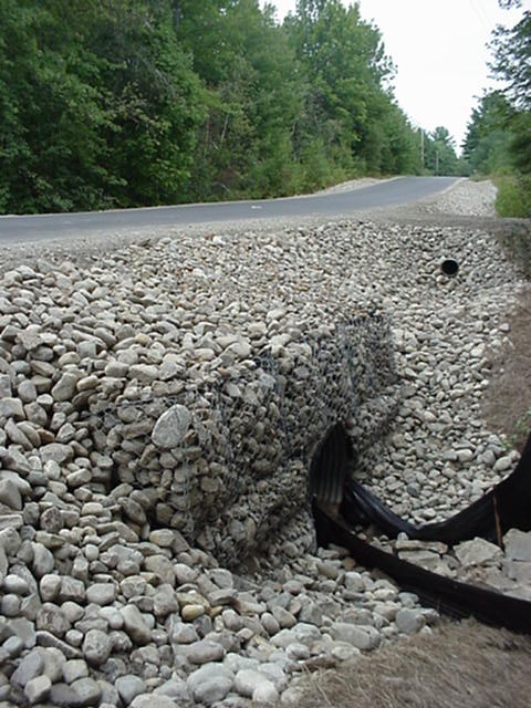 This elaborate KSWCD (2003) project used wire baskets with rock (gabions) to trap sediment and stabilize the crossing of a West Branch Sheepscot River tributary at Wingood Road in the Town of Windsor.
Dill et al. (2002) stated that one of the best ways to prevent NPS pollution from road sand was installation of sediment settling basins, working with town road crews and providing training and equipment to meet new BMPs. In the Sheepscot River Basin, KSWCD (2003) worked with the Maine Department of Transportation (MDOT) to install sediment traps to catch road sand, but maintenance is problematic. Use of volunteer labor is being considered to help with cleaning sediment traps as a short-term solution due to budget constraints. KCSWCD (2003) worked cooperatively with the Sheepscot Valley Conservation Association to win community support:
"The greatest benefit of the project has been to bring the problems of the watershed to the attention of the communities. The towns, the DOT and the residents of the watershed have become increasingly aware of the river and its problems. The towns in the watershed are more knowledgeable about NPS issues, maintenance practices and erosion control. Three of the towns were able to access technical and financial help on road issues they did not have the resources to address."
NRC (2003) suggested using models with GIS data to analyze cumulative effects. The extent of timber harvest area, road densities and road crossings would be used as indicators. Irland (2000) suggests the need for reshaping forest management to make it more compatible with maintaining biodiversity and meeting other competing uses for Maine's forests. NRC (2003) concurred with the latter point: "Diverse forest ecosystems are more resistant to rapid, undesirable changes and are more compatible with other forest uses than industrial tree farms."
References
Arter, B.S. 2002. Narraguagas Watershed Management Plan. Conducted in Cooperation with Project SHARE on behalf of the Narraguagas River Watershed Council, Cherryfield, ME. Funded from CWA Section 319h funds by the Maine Department of Environmental Protection. 86 p. Posted at www.salmonhabitat.org/nrwmp02.pdf
Dill, R., C. Fay, M. Gallagher, D. Kircheis, S. Mierzykowski, M. Whiting, and T. Haines, 2002. Water quality issues as potential limiting factors affecting juvenile Atlantic salmon life stages in Maine rivers. Report to Maine Atlantic Salmon Technical Advisory Committee by the Ad Hoc Committee on Water Quality. Atlantic Salmon Commission. Bangor, ME. 28 pp. [162kb]
Dunne, T., J. Agee, S. Beissinger , W. Dietrich, D. Gray, M. Power, V. Resh, and K. Rodrigues. 2001. A scientific basis for the prediction of cumulative watershed effects. The University of California Committee on Cumulative Watershed Effects. University of California Wildland Resource Center Report No. 46. June 2001. 107 pp.
Grant, J.W., J. Englert, and B.F. Bietz. 1986. Application of a method for assessing the impact of watershed practices: effects of logging on salmonid standing crops. North American J. Fish. Man. 6:24–31.
Halsted, M., 2003. From Branch Mills to the Pinhook: The history of settlement of the West Branch of the Sheepscot River. Sheepscot Valley Conservation Association. Alna, ME. 30 pp. [6.5Mb]
Haynes, R.W., R.T. Graham, and T.M. Quigley (Eds.). 1996. A Framework for Ecosystem Management In the Interior Columbia Basin And Portions of the Klamath and Great Basins. U.S. Forest Service and U.S. Bureau of Land Management with assistance from the Pacific Northwest Forest Experiment Station. PNW-GTR-374. 75 p.
Irland, L.C., 1998, Maine’s Forest Area, 1600-1995-Review of Available Estimates. College of Natural Sciences, Forestry, and Agriculture, University of Maine, Maine Agricultural and Forest Experiment Station. Miscellaneous Publication 736. 12 p.
Irland, L. 2000. Maine Forests: A Century of Change, 1900-2000 …and elements of policy change for a new century. Maine Policy Review, Winter, 2000: 66-77.
Jones, J.A. and G.E. Grant. 1996. Peak flow responses to clear-cutting and roads in small and large basins, western Cascades, Oregon. Water Resources Research. Vol. 32, No. 4, pages 959-974.
Kennebec Soil and Water Conservation District (KSWCD), 2003. Water quality restoration of the West Branch Sheepscot: Final report. Written for KSWCD by M. Halsted. Funded by Maine Department of Environmental Protection §319H Project #99R-30. 31 pp. [2.8Mb]
Maine Atlantic Salmon Task Force, 1997. Atlantic Salmon Conservation Plan for Seven Maine Rivers. 309 pp. [1.6Mb]
Maine Department of Conservation. 2004. Maine Forest Practices Act. Revised to include changes through July 1, 2004. Maine DOC, Maine Forest Service, Augusta, Maine. 13 p.
Maine Department of Environmental Protection. 1994. State of Maine 1994 Water Quality Assessment. MDEP, Augusta, ME.
Maine Forest Service. 1998. “Timber Supply Outlook for Maine: 1995-2045.” Maine Department of Conservation. Augusta, ME.
Maine Forest Service. 2002. The 2000-2001 Maine Forest Report on Forestry Best Management Practices Use and Effectiveness in Maine. Maine Department of Conservation, Augusta, ME.
National Marine Fisheries Service (NMFS) 1996. Coastal Salmon Conservation: Working Guidance for Comprehensive Salmon Restoration Initiatives on the Pacific Coast. September 1996. 5pp. [139kb]
National Marine Fisheries Service and U.S. Environmental Protection Agency. 2003. Maine Coastal Nonpoint Source Program NOAA/EPA Decisions on Conditions of Approval. US DOC, National Oceanic and Atmospheric Administration and US EPA. Washington D.C. 20 p.
National Marine Fisheries Service (NMFS) and U.S. Fish and Wildlife Service (USFWS). 2004. Draft Recovery Plan for the Gulf of Maine Distinct Population Segment of Atlantic Salmon (Salmo salar). National Oceanic and Atmospheric Administration, NMFS, and Northeastern Region USFWS. Silver Spring and Hadley, MA. 239 pp. [950 kb]
National Research Council, 2003. Atlantic Salmon in Maine. The Committee on Atlantic Salmon in Maine, Board on Environmental Studies and Toxicology, Ocean Studies Board, Division on Earth and Life Sciences. National Research Council of the National Academies. National Academy Press. Washington, D.C. 260 pp. [3.5Mb]**
Rieman, B.E., D.C. Lee and R.F. Thurow. 1997. Distribution, status and likely future trends of bull trout within the Columbia River and Klamath River Basins. No. Amer. Jour. of Fisheries Management. 17: 1111-1125.
Sheepscot River Watershed Council. 2000. Sheepscot River West Branch Riparian Inventory. Performed by the Sheepscot River Watershed Council with funding from the Maine State Office of Planning, Augusta, ME. 52 p.
Stafford, C., M. Leathers, and R. Briggs, 1996. Forestry-related non-point source pollution in Maine: A literature review. Maine Agricultural and Forest Experiment Station. College of Natural Resources, Forestry and Agriculture. University of Maine. CFRU Information Report 38. Miscellaneous report 399. Orono, ME. 20 pp. [200kb]