Bibliography Background About KRIS
Urban and Suburban Development and Potential Cumulative Effects on Gulf of Maine Atlantic Salmon
Paved surfaces or roof tops in urban or suburban areas alter runoff and hydrology of watersheds profoundly. For a discussion of how increases in impermeable surfaces effect aquatic resources, including Pacific salmon ecosystem case studies, see the general KRIS Background page on effects of urbanization. The National Research Council (2003) pointed out that the face of Maine's landscape has been constantly changing over the last 300 years due to "timber harvesting, clearing for agriculture, farm abandonment, industrial development, and more recently, residential land use" and that change is likely to continue. According to NRC (2003):
"Maine will likely experience increased demand for land, forest resources and marine and freshwater areas containing valuable salmon habitat. As in other coastal states, Maine will probably experience increased residential development of land along the coast and rivers that contain valuable salmon habitat. This will increase the pressure to expand Maine's road network, an activity that requires bridge construction or culverts over salmon streams."
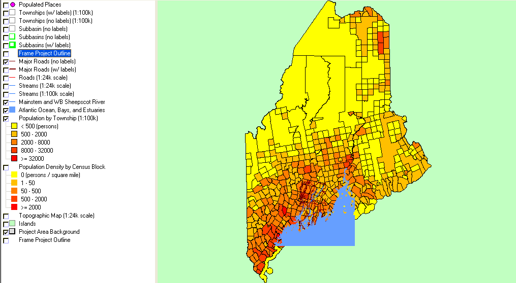 This U.S. Census Bureau map image from the KRIS Sheepscot database shows that population centers are mostly along the southern and mid-coast, with very sparse population in northeast Maine. Development pressures are likely to be greater in the short term for the Sheepscot and Ducktrap rivers, while less of a threat to DPS Atlantic salmon in Downeast rivers.
The Maine Department of Environmental Protection (MDEP, 1999) used aquatic macroinvertebrates to trace problems related to increasing total impervious area and loss of biodiversity. "Biological monitoring of the benthic macroinvertebrate community in urbanized watersheds has revealed severe degradation in the lower order streams. Streams with greater than 10% impervious cover appear to be the most affected."
Urbanization per se is not much of a current threat in Atlantic salmon DPS watersheds, but small parcel development for rural residences has the potential to fragment forests, increase road networks and associated nonpoint source sediment pollution (NRC, 2003). Other side effects could include nutrient and bacterial pollution from septic tanks and introduction of pesticides into water courses, especially if back yard chemicals are applied in stream side areas (U.S. EPA, 1983).
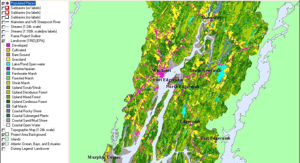 This U.S. Environmental Protection Agency land use and land cover map of the lower Sheepscot River basin shows the highest development along Route 1 in Wiscasset near the coastal inlets from the Gulf of Maine. Developed areas are those with substantial paving or total impervious area (TIA). This area is likely to continue to grow, along with challenges of controlling nonpoint source pollution. Map image from KRIS Sheepscot with data from U.S. EPA and is based on 1992 Landsat imagery.
Plantinga et al. (1999) tracked the recent history of forest cover changes in Maine and found that, while private timberland would likely decrease by 3% by 2050, that there was an expected increase of 56% for urban areas. Irland (2000), in discussing the history and future of Maine's forests, stated that management of large areas of rural land become more challenging as ownership fragments:
"From 1953 to 1993, the number of owners of forest parcels smaller than one hundred acres increased from 63,000 to 229,000. In northern Maine, policy must deal with a dozen or so owners. In southern Maine, it must deal with tens of thousands. In the coming century, parcels will fragment even further, especially in the spreading suburban fringe."
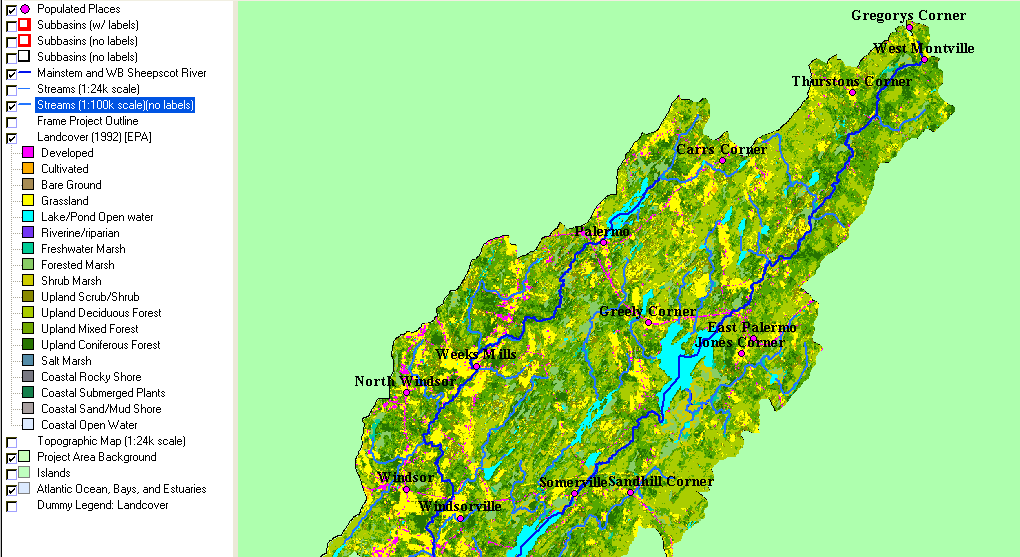 Much of the uplands of the upper Sheepscot River watershed are returning to deciduous and coniferous forests as shown by the U.S. EPA land use and land cover map based on 1992 Landsat data (at left). Indications of development show as linear features along roadways, but with further rural residential development this pattern could continue to disperse. Lowland areas adjacent to streams showing the signature of grass may indicate partial succession from past farming or current use as pasture. Map image from KRIS Sheepscot with data from U.S. EPA.
The National Marine Fisheries Service and U.S. EPA (2003) signed a Memorandum of Understanding (MOU) with the State of Maine with regard to nonpoint source pollution (NPS) in coastal watersheds, which included discussions on why the agencies felt the State was dealing adequately with problems related to urbanization. They cited the passage of the Maine Stormwater Management Law in 1997 that establishes storm water control standards that vary with the size of the development and the extent of previous cumulative watershed effects related to urbanization. Stormwater management plans are now required of developers on a sliding scale:
- Developments in "most at risk" watersheds required for 20,000 square feet of disturbance,
- One acre disturbance triggers this planning requirement in sensitive or threatened watersheds, and
- Development creating five acres of disturbance in any watershed.
NMFS and U.S. EPA (2003) report that the Maine Department of Environmental Protection has seen reductions in impervious area, as project designers proactively consider NPS early in the planning process.
The Maine Waste Discharge Law (38 M.R.S.A. §§ 411 et seq.) requires that municipalities adopt a comprehensive plan for stormwater related NPS pollution. Those municipalities that do not create such plans "will lose their authority to enforce all local land use ordinances, except for state-mandated shoreland zoning" (NMFS/U.S. EPA, 2003). Those municipalities that do comply are given preference in access to funds for infrastructure development and nonpoint source control.
 |
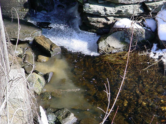 |
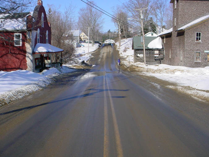
| The photo above shows the main road through a small town in the Sheepscot River basin during late winter with sand covering the road and discoloring the snow at the margins. As the snow melts, road sand washes into the nearby creek (at right). Photo by Melissa Halsted. | Sand and silt from the road margins flow into the stream as it passes through the town. This chronic NPS pollution can decrease the quality of aquatic habitat by decreasing insect productivity, filling pools and infiltrating potential spawning gravels for salmon in lower river reaches. Photo by Melissa Halsted. |
Solutions to NPS Problems Related to Urban and Suburban Development
As the NRC (2003) cautioned, the largest problem for Maine DPS Atlantic salmon watersheds will likely be related to suburban development of small parcels and extension of road networks. Erosion related to roads is already the target of restoration efforts in the Sheepscot River and other DPS rivers (see Roads and Upland Erosion page). Proper transportation planning and road design and engineering will help avoid unstable and ecologically sensitive areas and minimize erosion from the road bed itself.
 NMFS and U.S. EPA (2003) state that : "Limiting impervious surface is one of the most effective means of preventing storm water runoff since it reduces the volume of runoff created in the first place." Implementation of stormwater runoff plans by municipalities and close attention from State planning agencies will help decrease NPS as Maine grows in population.
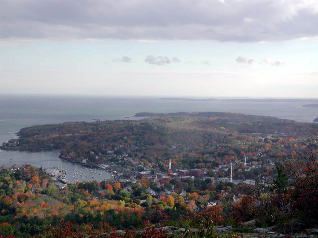
The photo at left shows Camden, Maine, with buildings only partly in view because of the abundance of trees. Maintaining park areas, commons and stream corridors, and minimizing paving around houses can decrease stormwater runoff.
Septic systems are often associated with rural residential development and they may be sources of bacterial pollution to streams (Halsted, 2002). If wetland areas are developed near streams, the drainage may not be compatible with typical septic systems and overboard discharge systems may be used (Dill et al., 2001). Dill et al. (2001) noted that these systems use chlorine, which is extremely toxic to salmonids, particularly if stream pH is low or temperature high and, consequently, pose potential problems for Atlantic salmon in the Narraguagus River. A possible solution is preventing development of parcels near Atlantic salmon DPS rivers that do not have sufficient drainage for normal septic systems.
With changing land uses and the increasing trend towards rural residential development the challenge will be to educate new residents, optimally with outreach efforts after changes in ownership. The Kennebec Soil and Water Conservation District (2003) and Sheepscot Valley Conservation Association have worked closely to inform the community and to take action to abate NPS pollution from roads and continuing similar efforts will be necessary. Dill et al. (2003) noted that the intensity of applications of pesticides for home use may be greater than some industrial uses, such as for forestry; therefore, special attention should be given to educate land owners with property bordering Atlantic salmon streams to prevent pesticide pollution.
Kircheis (2000) noted the use of easements in the Sheepscot River basin benefited Atlantic salmon conservation efforts:
"The Sheepscot Valley Conservation Association (SVCA).......protected several plots of land from development, including eight acres in Alna and 27 acres in Palermo through land acquisition. The Wellspring Land Alliance also purchased 100 acres in the headwater regions above Sheepscot Pond to enhance protection of the Sheepscot watershed."
Irland (2000) concluded that the unprecedented scale land acquisition by the State is occurring because "the public, increasingly suburbanized and cut off from nearby open lands, saw a need to expand Maine’s public estate." Extensive easements have been purchased or acquired on the Dennys River in its sensitive riparian zone (Kleinschmidt Assoc., 2002) and easements or acquisition of similar key parcels to protect habitat values may help minimize conflict over development, at least on the most problematic sites.
Even with good planning, on site use of BMPs and mitigation measures, there is still a risk of cumulative effects of disturbance (Wigmosta and Burges, 2001). Because of the complexity of challenges involved in planning in Atlantic salmon DPS watersheds, NRC (2003) suggested that spatial data or GIS and analytical tools such as modeling be applied. This study of cumulative effects could consider interactions and spatial relationships of such factors as roads, irrigation withdrawals and return flow, agricultural chemicals, riparian forest buffers, forest management, forestry best management practices (BMPs), recreational use and residential, commercial, and industrial development.
Wigmosta and Burges (2001) used analytical methods similar to those recommended by NRC (2003) in the Puget Sound area of Washington State to diagnose and help prevent impacts of urbanization. Jackson et al. (2001), as part of those studies, designed a more accurate model for changes in hydrology related to urbanization that allowed more accurate calculation of the needed size of detention basins or other storage as total impervious area increased. Previous models had not been accurate in predictions and had lead to planning controversies. King County funded and adopted this model for planning and taught all engineers involved in project design and review how it worked. This has avoided conflicts and allowed for maintenance of drainage while preventing damaging flood peaks.
References
Dill, R., C. Fay, M. Gallagher, D. Kircheis, S. Mierzykowski, M. Whiting, and T. Haines. 2002. Water quality issues as potential limiting factors affecting juvenile Atlantic salmon life stages in Maine rivers. Report to Maine Atlantic Salmon Technical Advisory Committee by the Ad Hoc Committee on Water Quality. Atlantic Salmon Commission. Bangor, ME. 28 pp. [162kb]
Irland, L. 2000. Maine Forests: A Century of Change, 1900-2000 …and elements of policy change for a new century. Maine Policy Review, Winter, 2000: 66-77. 12 pp. [300 Kb]
Jackson, C.R., S.J. Burges, X. Liang, K.M. Leytham, K.R. Whiting, D.M. Hartley, C.W. Crawford, B.N. Johnson, and R.R. Horner. 2001. Development and Application of Simplified Continuous Hydrologic Modeling for Drainage Design and Analysis. Pages 39-58 in: Wigmosta, M.S. and S.J. Burges (Eds.), Land Use and Watersheds: Human Influence on Hydrology and Geomorphology in Urban and Forest Areas. American Geophysical Union, Washington, D.C.
Kennebec Soil and Water Conservation District (KSWCD), 2003. Water quality restoration of the West Branch Sheepscot: Final report. Written for KSWCD by M. Halsted. Funded by Maine Department of Environmental Protection §319H Project #99R-30. 31 pp. [2.8Mb]
Kleinschmidt Associates. 2002. Dennys River Corridor Land Management Plan. Performed under contract to the Maine Atlantic Salmon Commission. Kleinschmidt Associates, Consulting Engineers and Scientists, Pittsfield, Maine. Posted at: http://www.state.me.us/asa/LMP%20Dennys/
Maine Department of Environmental Protection (MDEP). 1999. Biomonitoring retrospective: Fifteen year summary for Maine rivers and streams. MDEP. Note: A work in progress. Final version will be available in the final KRIS Sheepscot.
National Marine Fisheries Service and U.S. Environmental Protection Agency. 2003. Maine Coastal Nonpoint Source Program NOAA/EPA Decisions on Conditions of Approval. US DOC, National Oceanic and Atmospheric Administration and US EPA. Washington D.C. 20 p.
National Research Council, 2003. Atlantic Salmon in Maine. The Committee on Atlantic Salmon in Maine, Board on Environmental Studies and Toxicology, Ocean Studies Board, Division on Earth and Life Sciences. National Research Council of the National Academies. National Academy Press. Washington, D.C. 260 pp. [3.5Mb]**
Plantinga, A. J., T. Mauldin, and R. J. Alig. 1999. Land use in Maine: determinants of past trends and projections of future changes. U.S. Department of Agriculture, Forest Service. Pacific Northwest Research Station. Res. Pap. PNWRP-511. Portland, OR . 28 pp. [262 Kb]. Also at U.S. Forest Service PNW website: http://www.fs.fed.us/pnw/pubs/rp_511.pdf
Stafford, C., M. Leathers and R. Briggs. 1996. Forestry Related Nonpoint Source Pollution in Maine: A Literature Review. Cooperative Forestry Research Unit, University of Maine, Orono, ME. Miscellaneous Paper # 399. 20 p.
U.S. Environmental Protection Agency. 1983. Results of the Nationwide Urban Runoff Program. U.S. Environmental Protection Agency, Water Planning Division, Washington, D.C.U.S. Geologic Survey. 2004. Status and Trends of the Nation's Biological Resources. USGS, National Biological Survey. Internet website with numerous authors at http://biology.usgs.gov/s+t/SNT/index.htm.
Wagner, R.G and J.M. Hagan (Eds). 2000. Proceedings of a Conference: Forestry and the Riparian Zone. University of Maine, Orono. 88 p.
Wigmosta, M.S. and S.J. Burges. 2001.Land Use and Watersheds: Human Influence on Hydrology and Geomorphology in Urban and Forest Areas. American Geophysical Union, Washington, D.C. 227 p.