Bibliography Background About KRIS
Sheepscot River Info Links
Climate Data for the Sheepscot River Watershed
Climate data in KRIS Sheepscot were located by visiting the website of the Maine State Climate Office, which provides links to the NOAA's National Climatic Data Center. Available datasets include annual and monthly records of precipitation, temperature, and snowfall. Data incorporated into KRIS are from the Newcastle, Maine (Coop ID #175675) station.
US Geological Survey (USGS) Streamflow Data for the Sheepscot River
USGS streamflow data for the Sheepscot River comes from the USGS NWISWeb. Data are from the US Geological Survey gauging station 01038000, Sheepscot at North Whitefield. The USGS finalizes and publishes the daily data in a series of water-data reports. Daily streamflow data and peak data are updated annually following publication of the reports. Annual peak flow and daily average flow records are reported in cubic feet per second. Water years (WY) begin on October 1 of the prior calendar year. For example, the 1998 water year started on October 1, 1997 and ended on September 30, 1998. See the Stream Flow Background page for more information. A recently published USGS analysis of changes in Maine's climate over the 20th century stated that spring runoff has become earlier, water content in snow pack for March and April has decreased, and the duration of river ice has become shorter (Dudley, 2002).
Trends in Streamflow, River ice, and Snowpack for Coastal River Basins in Maine During the 20th Century
Dudley and Hodgkins (2002) examined trends in streamflow, river ice, and snowpack for coastal river basins in Maine over the 20th Century. Trends over time were tested in the timing and magnitude of seasonal river flows, the occurrence and duration of river ice, and changes in snowpack depth, equivalent water content, and density. Significant trends toward earlier spring peak flow and earlier center-of-volume runoff dates were found in the extended streamflow record spanning 1906-21 and 1929-2000. Only one of the six coastal rivers in the study analyzed for trends in cumulative runoff, the Sheepscot River, had a significant change in total annual runoff volume. Last spring river-ice-off dates at most coastal streamflow-gaging stations examined are trending to earlier dates. Trends in later fall initial onset of ice also were evident, although these trends are significant at fewer stations than that observed for ice-off dates. The longest, most complete snow records in coastal Maine indicated an increase in snow density for the March 1 snow-survey date during the last 60 years. The historical trends in streamflow, ice, and snow are all consistent with an earlier onset of hydrologic spring conditions in coastal Maine.US Geological Survey (USGS) Water Quality Data for the Sheepscot River
USGS water quality data for the Sheepscot River comes from the USGS NWISWeb. Data are from the US Geological Survey gauging station 01038000, Sheepscot at North Whitefield. The USGS collects and analyzes chemical, physical, and biological properties of water from across the Nation. Data are discrete samples typically collected by a variety of projects ranging from national programs to watershed scale studies. The Sheepscot River database includes: water temperature, dissolved oxygen, pH, and specific conductance with supporting air temperature data. See the Water Quality Background page for more information on water quality parameters.
Water Quality Data from the Maine Department of Environmental Protection
From 1984 to the present the MDEP (1999) has collected aquatic macroinvertebrate data for many of Maine's rivers. These data show trends in health of these water bodies using metrics like the EPT, Richness, Hilsenhoff, and Shannon-Weiner indices. The MDEP (1999) report also covers an overview of historical findings, the evolution of analytical techniques, and some useful case studies. Overall trends show an improvement from abatement of point source pollution problems but a decline in some rivers in recent years due to non-point source water pollution increases.
For general information on water quality and references to key literature, see the Water Quality Background page.
Water Quality Data from the Maine Atlantic Salmon Commission
The Maine Atlantic Salmon Commission (ASC) conducted synoptic water quality sampling across Maine's salmon rivers on May 7, July 29, and October 28 in the year 2003. Data collected included CLPH, EQPH, ANC, PCU (Apparent Color), CON (Conductivity in µmho/cm). The primary focus of the study was to compare pH values across Maine's salmon rivers. Acidification (low pH) water may be a factor limiting Atlantic salmon in Maine's downeast rivers (Maine TAC, 2002), though it is likely not a problem in the Sheepscot River.
For general information on water quality and references to key literature, see the Water Quality Background page.
Water Quality Data for Sheepscot Lakes by the Maine Volunteer Lakes Monitoring Program
The Maine Volunteer Lake Monitoring Program (MVLMP) is a statewide nonprofit organization dedicated to the protection of Maine’s lakes and ponds through the acquisition of scientific data, and to enhancing public awareness about the sensitivity and value of Maine's water resources. In 2003, over 450 volunteers collected water quality data on over 330 Maine lakes. MVLMP volunteers attend training workshops, and quality assurance/quality control and technical oversight are provided by the Maine Department of Environmental Protection. Data are published in PEARL (Public Educational Access to Environmental Information in Maine), a statewide online database produced by a collaboration of state and federal government agencies, universities, and non-governmental organizations. MVLMP data for Sheepscot River watershed lake are included in KRIS. MVLMP published annual report (Williams, 2002 and Williams, 2003) that summarize data and provide details on data collection and quality assurance/quality control methods.
For general information on water quality and references to key literature, see the Water Quality Background page.
Water Quality Data from the Sheepscot Valley Conservation Association
The Sheepscot Valley Conservation Association initiated an extensive water quality monitoring program in the Sheepscot River watershed in 1994. Its staff and volunteers conduct data on parameters including dissolved oxygen, bacteria, temperature and salinity. Pugh (2002) summarizes the 1994-2001 data, Abello (2002) summarizes 1994-2002, and Gambrel (2003) summarizes 1994-2003 season, and Arter (2004) more briefly summarizes the 1994-2003 data. The source table included in KRIS contains 3121 samples at 45 sites (see table and map of sampling locations).
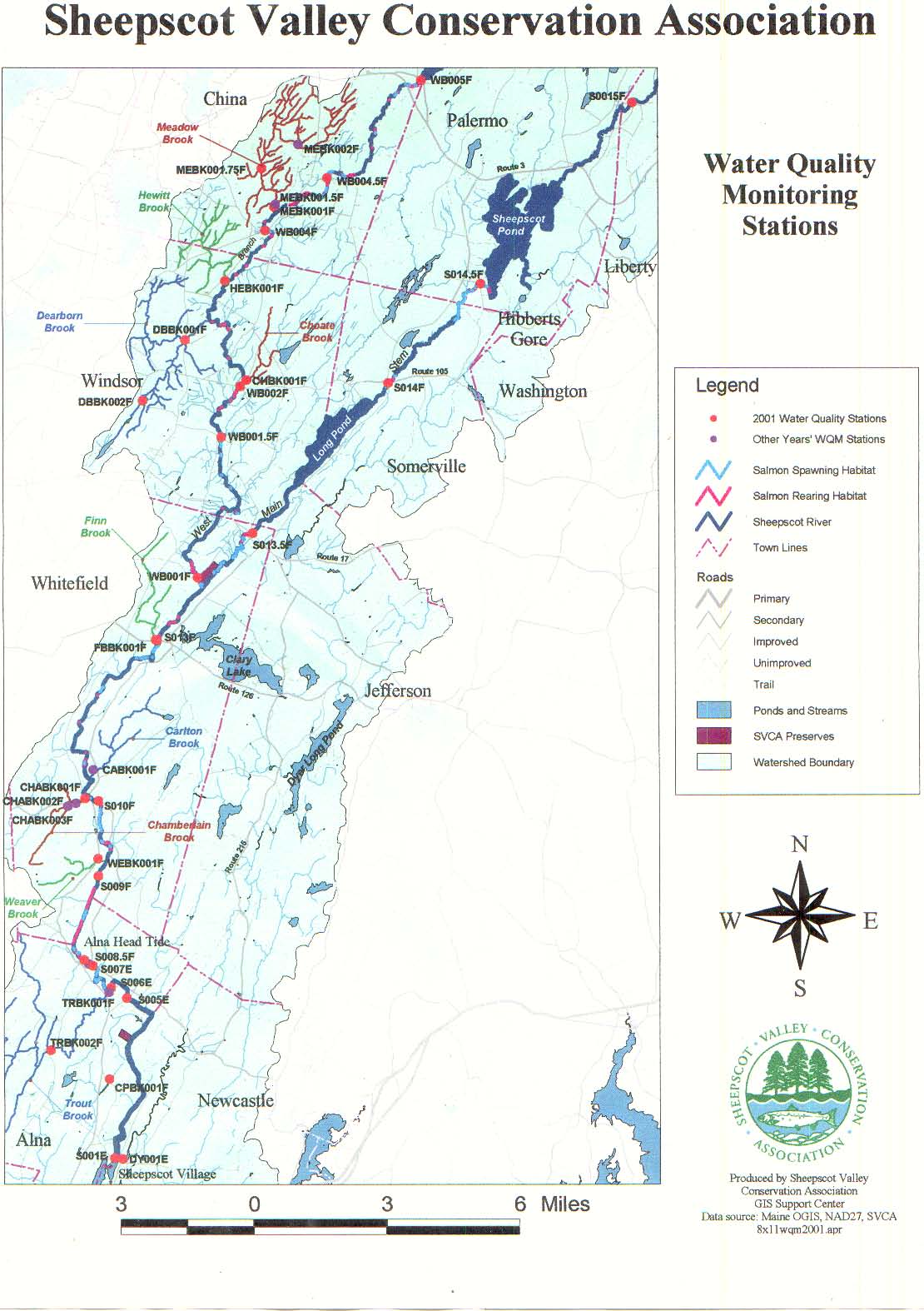
For general information on water quality and references to key literature, see the Water Quality Background page.
Automated Probe Water Quality Data for the Lower Sheepscot River from NOAA Fisheries
For general information on water quality and references to key literature, see the Water Quality Background page.
Pesticide Monitoring in Maine Atlantic Salmon Rivers by the Maine Board of Pesticides Control
The Maine Board of Pesticides Control conducted a study of pesticide contamination in seven of Maine's salmon-bearing rivers and their tributaries in late September 1997 (Chizmas 1999). Rivers sampled included the Dennys, Ducktrap, East Machias, Macmas, Narraguagus, Pleasant, and Sheepscot. Samples were analyzed for 33 pesticide chemicals and degradation (metabolic breakdown) products. Hexazinone, the only chemical detected, was present in 19 (29.4%) of the 64 samples collected. KRIS Sheepscot contains both summary and raw data from this study.
The Maine Atlantic Salmon Task Force (1997) noted that agricultural pesticides are known to be used in the Sheepscot watershed and are a potential treat to salmon habitat, but rated the threat as a low priority. Dill et al. noted that the water-soluble herbicide atrazine is applied to several hundred acres of forage corn in the Sheepscot watershed and that insecticides and miticides (diazinon, chlorpyrifos, fluvalinate, permethrin, fenvalerate, and dicofol) and herbicides (simazine, atrazine, oryzalin, clopyralid [Stinger], and glyphosate) are applied to approximately 100 acres of Christmas tree farms in the Sheepscot watershed. This document also describes a 1992 Maine Board of Pesticide Control groundwater study that included two sites in Windsor and one in North Newcastle, both in the Sheepscot watershed. One of wells sites at Windsor had an atrizine residue reading at less than established drinking water guidelines and the other two samples did not have detectable levels of any of the herbicides.
The Maine Department of Environmental Protection has issued several reports that include data and discussion of pesticides in Maine's Salmon Rivers, including Whiting (2001a). Dill et al. (2003) includes an addendum on pesticide usage that summarizes the findings of pesticide sampling and research in the state of Maine.
Stream Temperature Monitoring in the Sheepscot River Watershed
Stream temperature can be the single most critical feature of habitat for salmonids and other aquatic organisms, and is relatively easy to monitor. The Maine Atlantic Salmon Commission (ASC) has compiled a database of continuous recording temperature probe data collected in the Sheepscot River watershed by the Sheepscot River Watershed Council, the Sheepscot Valley Conservation Association, Maine Atlantic Salmon Commission, US Fish and Wildlife Service, and NOAA Fisheries (see table of temperature probe locations). All 1994-2003 temperature data in the database are included in KRIS Sheepscot as a source table. Automated probe water temperature data from the Maine Department of Environmental Quality's biomonitoring program (see draft standard operating procedures and map) are not included in the ASC database, and are included in KRIS in a separate source table. Additional temperature data have been collected as one of the parameters in discrete water quality sampling programs, such as the Maine Department of Environmental Quality's salmon program. Arter (2004) lists all the temperature data being collected in the watershed.
High summer water temperature have been mentioned as a possible limiting factor for Atlantic salmon in the Sheepscot by several authors, including Maine TAC (2002), Arter (2004) and Pugh (2002). The KRIS project uses the floating weekly maximum temperature (FWM), or the average of seven daily maximum values around a date, to compare water temperature regimes across sites and in various years. Because peaks are smoothed, it is easier to graphically compare floating weekly maximum temperatures than it is to come daily maximum temperatures. On floating weekly maximum charts, two reference values are shown. The optimum range for juvenile Atlantic Salmonid growth is 15 ºC -19.0 ºC (DeCola, 1970) and juveniles stop feeding when temperatures exceed 22.5 ºC (Elliott, 1991). In KRIS charts that show minimum winter temperatures, a reference value of 3.8 ºC is shown as the temperature at which juveniles stop feeding (Elliott, 1991).
For more in-depth information on water temperature and references to key literature, see the Temperature Background page.
Historical Salmon Counts from US Fish and Wildlife Services
From 1956-1959, the US Fish and Wildlife Service operated a weir below Head Tide Dam on the Sheepscot River to study Atlantic salmon. They trapped, counted, and marked both upstream-migrating adults and downstream-migrating juveniles. Methods, results and discussion of the project are written up in a report by Stickney (1959), and data from that report were included in KRIS Sheepscot. For information on Atlantic salmon and other fish of the Sheepscot River watershed, and techniques used to measure them, see the Fish Populations Background page.
Sheepscot Habitat Surveys by the Maine Atlantic Salmon Commission and US Fish and Wildlife Service
The Maine Atlantic Salmon Commission and US Fish and Wildlife Service conducted Atlantic salmon stream habitat surveys in 1997-1999 for the most of West Branch and mainstem Sheepscot River, as well as several small tributaries. Habitat data presented in KRIS charts are summarized by sub-reach to allow comparison between locations. Also included in KRIS are GIS maps of habitat data and source tables listing data by habitat unit. Additional habitat surveys have been conducted in recent years in the Sheepscot River watershed, but the data has not yet undergone the quality assurance and quality control steps necessary for it to be released to the public, and were therefore not included in KRIS. Habitat survey methodologies and data processing procedures are described in Wright and Horton (1997).
Fisheries Data from the Maine Atlantic Salmon Commission
The Maine Atlantic Salmon Commission (ASC) has compiled many databases of fisheries information for Maine's salmon rivers, including the Sheepscot. Types of samples include rod catch, electrofishing, and weir counts. For information on Atlantic salmon and other fish of the Sheepscot River watershed, and techniques used to measure them, see the Fish Populations Background page.
Rod catch: Between 1948 and 1995, the Maine Atlantic Salmon Commission (ASC) has recorded the number of adult Atlantic salmon reported caught in the Sheepscot River watershed. This chart shows the number of Atlantic salmon caught each year in the Sheepscot River from 1948-1995. These numbers are reported catches and should be regarded as minimum counts because it is likely that not all catches were reported. Meister (1982) estimated that these counts represent approximately 60-80% of the actual number of fish caught.
Electrofishing: The ASC has compiled a database of electrofishing data collected in the Sheepscot River watershed by the the Maine Atlantic Salmon Commission, US Fish and Wildlife Service, and NOAA Fisheries. Data from 278 surveys for the years 1958-2003 are included in KRIS Sheepscot. Multiple passes were conducted in 69 of those surveys, allowing the ASC to calculate densities of Atlantic salmon parr and/or young-of-the-year. Other species besides salmon were also sometimes recorded, showing the fish species composition of the Sheepscot River watershed.
Weir: The ASC has compiled the results of three years of the US Fish and Wildlife Service's trapping of adult Atlantic salmon at its weir in Alna on the lower Sheepscot River. The weir was operated from 1994-1996 and data was collected for each fish caught, such as length, weight, age, scale samples, and genetic samples.
Spawner surveys: KRIS Sheepscot contains data on the number of redds observed during ASC spawner surveys conducted in the Sheepscot River and its tributaries from 1984 to 2002. A total of 544 redds were observed in 81 surveys. The ASC uses spawner surveys to track population trends and also to help determine where to stock hatchery salmon fry to avoid competition with wild salmon.
Sheepscot Smolt Trapping by NOAA Fisheries
The NOAA Fisheries operates rotary screw traps to capture downstream migrant Atlantic salmon smolts each spring on the Sheepscot River just below Head Tide dam in Alna. One trap was operated in 2001, and two were operated in 2002 will likely continue in future years. The dam passes water through two chutes, so when only one trap is operating, only half the flow of the river is flowing by the trap. Trap operators attempted to catch the largest number of smolts possible while minimizing the number of shad captured. This was done by adjusting the traps' positioning when large numbers of shad were caught. No mark-recapture techniques were used to evaluate trap efficiency, so population size estimates cannot be made from the data. The smolt study is still in progress, so no reports have been written detailing the methods and results, but NOAA Fisheries states that once four years of data have been collected, it will write a report and release additional data.
For information on Atlantic salmon and other fish of the Sheepscot River watershed, and techniques used to measure them, see the Fish Population Background page.
Hatchery Stocking Records from the US Fish and Wildlife Service
The US Fish and Wildlife Service maintains a database of Atlantic salmon stocked in the Sheepscot River watershed from National Fish Hatcheries. Data for 1957-2003 are included in KRIS. Data includes strain origin and life-stage stocked. From 1957 to 1991, most of the fish stocked were from older age classes and came from various salmon rivers. In 1992, a river specific stocking program started using mostly fry. For more information, see the Hatcheries Background page.
Alewife Data from the Maine Department of Marine Resources
The Maine Department of Marine Resources regulates and monitors the catch of alewives in the Sheepscot River watershed. All alewife data in KRIS were extracted from a PowerPoint presentation given by Tom Squiers at the Sheepscot River Symposium on October 6, 2004 in Wiscasset, Maine. The presentation is available in KRIS as part of the symposium proceedings (Laser, 2004). For information on Alewives and other fish of the Sheepscot River watershed, and techniques used to measure them, see the Fish Population Background page.
Fisheries and Lake Survey Data from the Maine Department of Inland Fisheries and Wildlife
The Maine Department of Inland Fisheries and Wildlife (IFW) conducts surveys and maintains several databases for the state of Maine. Their research and monitoring focuses on the non-anadromous freshwater fish such as brook trout and brown trout. For information on the native and non-native fish of the Sheepscot River watershed and techniques used to measure them, see the Fish Population Background page.
Fish Stocking: The IFW stocks fish in Maine lakes and rivers, including ten lakes in the Sheepscot watershed. The majority fish stocked were native brook trout, but also stocked were nonnative fish brown trout and splake (a hybrid of speckled trout and lake trout). The magnitude and effect of brown trout and splake predation on the Sheepscot's Atlantic salmon population unknown. "Landlocked" Atlantic salmon were also stocked in Long Pond. For a discussion of hatcheries, see the Hatcheries Background page.
Brook Trout Monitoring Project: The IFW conducts multi-pass electrofishing surveys annually at seven index sites across the state of Maine to monitor brook trout populations. One of the sites, Alna Stream, is located in the Sheepscot River watershed and the data is included in KRIS for the years 2001 to 2003. The focus of the study is brook trout, but all fish species captured are weighed and measured. The Fisheries Research section of IFW's (2004) Wildlife and Hatcheries Annual Report contains a description of the Brook Trout Monitoring Project.
Electrofishing: The IFW conducted electrofishing surveys from 1999-2001 in the Sheepscot River watershed and compiled the information into a database, including GIS locations of each survey. Most locations surveyed were small tributaries to the Sheepscot and provide an excellent compliment to the Maine Atlantic Salmon Commissions electrofishing efforts, which focus on the mainstem and West Branch Sheepscot and larger tributaries.
Lake Surveys: The IFW has compiled a database of fish species that are present in Maine lakes and ponds. Data for most of the larger waterbodies in the Sheepscot watershed are included in KRIS. In addition, IFW has produced 2-page surveys for many lakes. The first page of each survey is map of the lake showing water depth at many locations in the lake. The second page lists the fish species present in the lake and provides a brief narrative about the lake. Surveys for the many Sheepscot River watershed lakes are included in the Bibliographic Resources section of KRIS:
| Lake or Pond Name: |
|
|
Historical Surveys of Sheepscot River and Lakes
The Atlantic Sea Run Salmon Commission (now known as the Maine Atlantic Salmon Commission) conducted several surveys of the Sheepscot River in the 1950s. Bryant (1956) is a survey of the Sheepscot and Ducktrap Rivers. It includes information on flow, substrate, fish populations, and tributaries, dams, and other barriers. Most uniquely, it includes a thermograph showing daily minimum and maximum temperatures in the Sheepscot River at Whitefield from April through September 1956. A comparison of the 1956 temperature data with more recent data from the 1990s indicates that the Sheepscot River has warmed since the 1960s. Bryant (1950) surveyed the Sheepscot in 1950 and provides narrative descriptions of many locations along the West Branch Sheepscot River. Scanned photographs from the Bryant surveys are included as photo tours in KRIS.
KRIS Sheepscot includes 1953-1963 historical surveys of lakes, including Bowler Pond (AKA Belton Pond), Branch Pond, Chisholm Pond, Turner Pond (AKA Turner Mill Pond), Beech Pond, Long Pond, and Sheepscot Pond. These surveys contains information such as lake size, lake depth, and fish species present in the lakes. Also present are contemporary lakes surveys
Agricultural Census Data for Sheepscot River Watershed Counties
Beginning in 1840, the U.S. Department of Commerce, Bureau of the Census, conducted a census of US agriculture every 5 to 10 years. In 1997, authority to conduct the census was shifted to US Department of Agriculture (USDA), National Agricultural Statistics Service (NASS). Data are aggregated by county and data for 1987, 1992, and 1997 are available on the AgCensus web site. KRIS Sheepscot contains data for Kennebec, Lincoln, and Waldo counties.
Historical Census Data for Sheepscot River Watershed Counties
The US Geological Survey has assembled historical census data for every county in the United States. Data include the total human population (1790-1990) and acres of improved cropland (1850-1990), and census data were collected every 5-10 years. Data for Kennebec, Lincoln, and Waldo counties were downloaded from US Geological Survey web site and included in KRIS Sheepscot. Spatial metadata were downloaded along with the data.
Human Population and Land Use in Sheepscot Watershed by Maine State Planning Office
A representative from the Maine State Planning Office presented information on Sheepscot land use trends at the Sheepscot River Watershed Symposium in October 2004. Data in KRIS were extracted from her PowerPoint presentation. The presentation is available in KRIS as part of the symposium proceedings (Laser, 2004). For information on how increasing human populations affects Atlantic salmon, see the Background pages on Development / Total Impervious Area and Roads and Erosion.
Historic Topographic Maps from the University of New Hampshire
The University of New Hampshire has scanned historical topographic maps and published them on their web site. Maps are available by quadrangle for many time periods from approximately 1860 to 2000. The topographic maps are in a JPEG format and are not geo-referenced, so cannot be added to a GIS without significant effort, but are still useful because they are a unique tool for comparing land use changes over time. Halsted (2003) used the maps to compare land use changes over time at key locations in the West Branch Sheepscot watershed. Many of the historic topographic maps included in KRIS tour topics are for the same locations described in Halsted (2003). These maps vary in their detail, with older maps generally being larger-scale and less detailed, and users should keep this in mind when using the maps.
The new KRIS Map Viewer allows complete access to spatial data layers for KRIS Sheepscot database users. Maps were assembled into a companion ArcView project called KRIS Sheepscot Maps, available on a separate CD-ROM. Map data in the KRIS Sheepscot were assimilated from many different sources, including: the Sheepscot Valley Conservation Association, US Geological Survey, Maine Office of Geographic Information Systems , US Fish and Wildlife Service, Maine Department of Environmental Protection, Maine Atlantic Salmon Commission, US Environmental Protection Agency, Spatial Climate Analysis Service at Oregon State University, US Department of Commerce, Bureau of the Census, Maine State Planning Office, Maine Cooperative Fish and Wildlife Research Unit at the University of Maine Orono, USDA-Natural Resource Conservation Service, and US Army Corp of Engineers.
Map themes have a readily-accessible companion metadata file that describes the map theme and provides contact information for the source of that theme (though not all metadata has been incorporated into KRIS at the time of this draft). If KRIS is installed on your computer's hard drive and you are viewing maps using the KRIS Map Viewer (the map tab), you can view metadata for a layer by clicking on a layer in the map legend to make it the active theme and then clicking the "M" (metadata) button on the toolbar. If you are browsing KRIS on the www.krisweb.com Internet site, or viewing the web pages included on the KRIS CD-ROMs, you can view map metadata by clicking on a metadata link at the link at the bottom of a map page.
Kennebec Soil and Water Conservation District Photos
Melissa Halsted of the Kennebec Soil and Water Conservation District has contributed photographs of the streams, dams, landscape in the Sheepscot River Watershed. Currently in KRIS, there is one photo tour for each sub-basin, but many more tours will be included at a later date.
Photo Tours from a Combination of Sources
Most KRIS photo tour topics contain photos from a single source. However, sometimes it is beneficial to combine photos from multiple sources into a single tour to group photos of a particular site or theme and make comparisons. For these combination topics, please read the caption below each photo to learn who the photographer is. For contact information and background information on a particular photographer, look for another photo tour topic that includes pictures from the same photographer, and read the Info Link or metadata.
Historical Photographs of Sheepscot River Watershed
KRIS contains historical photographs of the Sheepscot River watershed. The source for these photo are a 1950 Atlantic Sea Run Salmon Commission habitat survey (see Bryant, 1950 for report without photos), Old Time Prints in Wiscasset, and local historical societies.
Note about documents in KRIS