Bibliography Background About KRIS
Channel Processes
The velocity of a stream, as much as any single factor, is responsible for determining the size of particles a stream can transport, as well as the way in which it carries the particles, or load (Larson and Birkland, 1994). Velocity is dependent on several factors which are discussed below.
 Gradient: In general, the higher the gradient, the faster the flow or increasing
velocity. Streams often begin in steep mountainous areas and fall precipitously
in headwater tributaries. Channels of greater than 12% gradient are considered
by geologists to be source reaches since any material falling into a channel
of that steepness in a storm event will immediately move down stream (Lunetta,
et al., 1997). Streams tend to flow down into reaches of lesser gradient
(4-12%) as they drop in elevation, but often remain in fairly incised canyons.
These are known as transport reaches because materials still tends to move
through these areas because of high hydraulic energy. When streams drop
below 4% gradient and their channels are unconfined, the energy of the stream
drops and sediment tends to remain in residence for longer periods. These
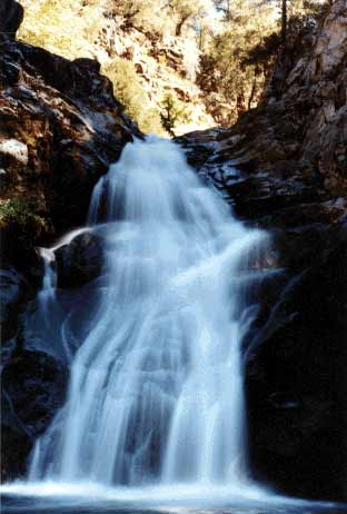
areas are classified as response reaches (Lunetta et al., 1997). Steinacher
Creek goes over waterfall just above its convergence with Wooley Creek,
the Salmon River's wildest tributary.
Gradient: In general, the higher the gradient, the faster the flow or increasing
velocity. Streams often begin in steep mountainous areas and fall precipitously
in headwater tributaries. Channels of greater than 12% gradient are considered
by geologists to be source reaches since any material falling into a channel
of that steepness in a storm event will immediately move down stream (Lunetta,
et al., 1997). Streams tend to flow down into reaches of lesser gradient
(4-12%) as they drop in elevation, but often remain in fairly incised canyons.
These are known as transport reaches because materials still tends to move
through these areas because of high hydraulic energy. When streams drop
below 4% gradient and their channels are unconfined, the energy of the stream
drops and sediment tends to remain in residence for longer periods. These
areas are classified as response reaches (Lunetta et al., 1997). Steinacher
Creek goes over waterfall just above its convergence with Wooley Creek,
the Salmon River's wildest tributary.
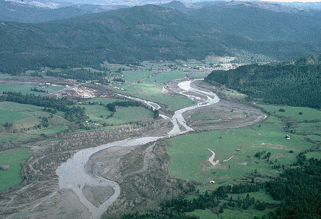
Valley Width and Confinement: Wide, shallow rivers have more contact with bed and therefore more friction. Entrenched rivers have less friction because they have a very low perimeter for contact with the water. Streams will increase in width when sediment supply exceeds transport capacity as shown by the Van Duzen River below Yager Creek. As the channel widens in response to sediment over-supply, its loses its defined riparian zone.
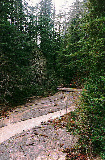
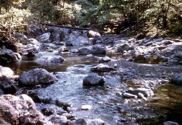 Roughness
of Sides and Bottom of Channel - A smooth stream bottom allows a higher
velocity while boulders or cobble slow the flow. The size of particles on
the stream bed are also a function of gradient and confinement. The photo
at left shows a tributary of the New River adjacent to the Trinity Alps
Wilderness.
Roughness
of Sides and Bottom of Channel - A smooth stream bottom allows a higher
velocity while boulders or cobble slow the flow. The size of particles on
the stream bed are also a function of gradient and confinement. The photo
at left shows a tributary of the New River adjacent to the Trinity Alps
Wilderness.
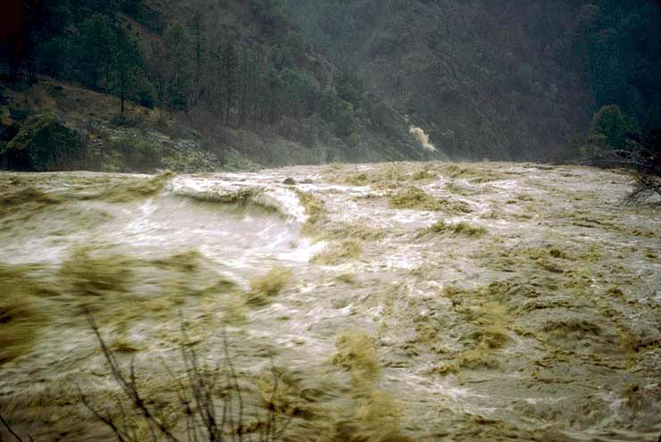
Discharge: Increasing flows means less contact with the perimeter of the stream bed as the water gets deeper and; therefore, greater velocity. Peak flood flows drive high sediment transport and often sediment in transit on the stream bottom may be many feet deep. The photo is of the Salmon River during the 1964 flood.

Dominant Discharge:The streamflow that is responsible for transporting the majority of the sediment and is responsible for creating or maintaining the characteristic size and shape of the channel is know as the channel forming flow or the dominant discharge (Leopold et al., 1964, Knighton 1984).The maximum sediment transport usually occurs at relatively moderate flow events rather than large flow events since moderate flows occur much more frequently than larger events.In channels at or near dynamic equilibrium, the dominant discharge is approximately equal to the bankfull discharge or the flow that fills the channel from bank to bank before spilling into the floodplain (Leopold et al., 1964). In streams that have been significantly incised, the dominant discharge is typically less than the bankfull discharge. This is the Navarro River, at Hendy Woods State Park, in December 2002.
 Amount
of Sediment: Greater sediment transport slows the velocity of a stream
and in the extreme make it a slurry of debris, then solid. The photo at
left was taken just after the January 1, 1997 when a debris torrent inundated
Bear Creek, tributary to the lower Eel River in Humboldt County. Pacific
Watershed Associates (1998) found that the stream bed had been buried 8-15
feet deep. They also found that debris torrent run-out distances were inordinately
long because the slides feeding the torrent had recently been logged and
there was little large wood entrained to form check dams and meter sediment.
Amount
of Sediment: Greater sediment transport slows the velocity of a stream
and in the extreme make it a slurry of debris, then solid. The photo at
left was taken just after the January 1, 1997 when a debris torrent inundated
Bear Creek, tributary to the lower Eel River in Humboldt County. Pacific
Watershed Associates (1998) found that the stream bed had been buried 8-15
feet deep. They also found that debris torrent run-out distances were inordinately
long because the slides feeding the torrent had recently been logged and
there was little large wood entrained to form check dams and meter sediment.
While it is well recognized that streams carry sediment, the mechanisms of sediment movement are still under study. Three different types of transport are recognized, however, sediment that is 1) in solution, 2) in suspension or 3) moving as bedload. The size of particles a stream can transport, or its competenc, depends primarily on velocity.
Increased sediment transport is associated with increasing flows. The velocity of water required to mobilize clay is approximately equal to the amount needed to mobilize sand but once in motion clay will tend to stay suspended longer. Capacity is the potential load a stream can carry, which is a function of gradient and flow. The capacity is the potential for movement while the load is the actual amount of material moved.
A stream in equilibrium is said to be “at grade” but will respond to any changes in flow or sediment supply. A stream loaded in excess of its capacity will deposit the load. When a stream bed fills in as a result of bedload exceeding capacity it is said to be aggraded. Increases in bedload may make a channel much shallower and wider, which in turn reduces the ability to hold high stream flows and increases flood frequency.Conversely, a stream with reduced bedload supply may have a capacity greater than its load and will down cut in order to increase its bedload, which is called degrading.
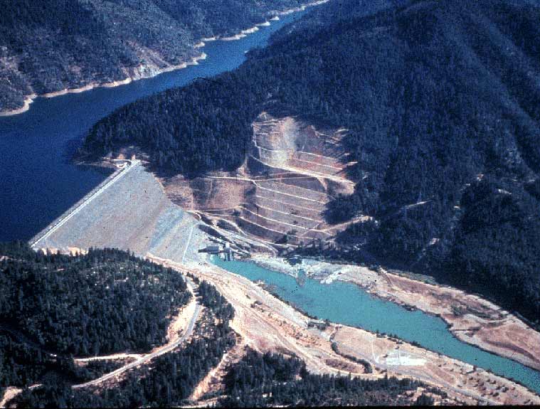 Dams trap sediment
and starve stream reaches downstream. The bed particle size will tend to
become larger as bedload transport during high water wash away smaller particle
sizes, like spawning gravels, with the dam blocking new recruitment. Alternatively,
flows below dams are lessened which decreases velocity and capacity of the
stream. In some cases, such as in the area below Lewiston Dam on the Trinity
River, lower flows may allow encroachment of riparian vegetation and major
changes in channel morphology which reduce juvenile salmon survival (USFWS,
2000).
Dams trap sediment
and starve stream reaches downstream. The bed particle size will tend to
become larger as bedload transport during high water wash away smaller particle
sizes, like spawning gravels, with the dam blocking new recruitment. Alternatively,
flows below dams are lessened which decreases velocity and capacity of the
stream. In some cases, such as in the area below Lewiston Dam on the Trinity
River, lower flows may allow encroachment of riparian vegetation and major
changes in channel morphology which reduce juvenile salmon survival (USFWS,
2000).
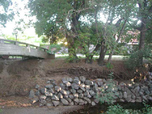 If a stream
bed is narrowed or confined to allow development in its riparian zone, this
also changes the equilibrium of the stream. The faster velocity caused by
the confinement increases the streams capacity and the stream begins to
down cut. This down cutting may move upstream in what is known as headward
erosion causing banks to fail upstream and gullies to form in headwater
areas or tributaries. Urbanization also increases stream runoff because
water is no longer absorbed by soil and vegetation in areas that have been
paved or otherwise remain impervious. Flood peaks in streams with a high
amount of total impervious area are larger than ones in streams without
urbanization.
If a stream
bed is narrowed or confined to allow development in its riparian zone, this
also changes the equilibrium of the stream. The faster velocity caused by
the confinement increases the streams capacity and the stream begins to
down cut. This down cutting may move upstream in what is known as headward
erosion causing banks to fail upstream and gullies to form in headwater
areas or tributaries. Urbanization also increases stream runoff because
water is no longer absorbed by soil and vegetation in areas that have been
paved or otherwise remain impervious. Flood peaks in streams with a high
amount of total impervious area are larger than ones in streams without
urbanization.
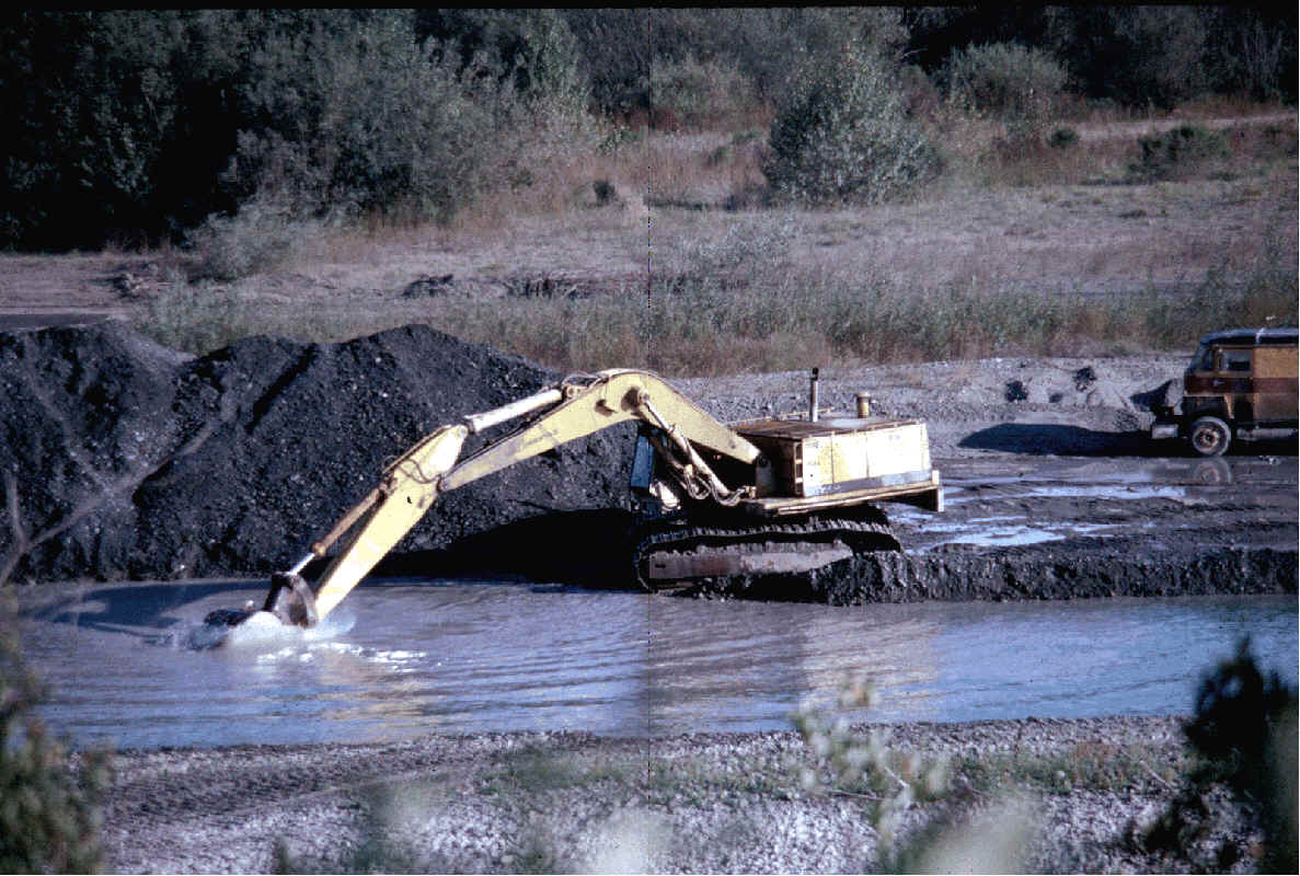 Gravel extraction
is another factor that can substantially reduce material that would otherwise
be available as bedload. The extraction lowers the elevation of the stream
bed and headward erosion may occur. Rivers also use bedload to build terraces
and focus the energy of the stream, which helps to scour out corner pools
in alluvial reaches. Removal of gravel from a stream will have a tendency
to flatten its profile both upstream and downstream of the site of extraction.
Gravel pits in river terraces may have a profound effect on surface water-ground
water interactions (see Ground Water page). Photo by Lewis Klein.
Gravel extraction
is another factor that can substantially reduce material that would otherwise
be available as bedload. The extraction lowers the elevation of the stream
bed and headward erosion may occur. Rivers also use bedload to build terraces
and focus the energy of the stream, which helps to scour out corner pools
in alluvial reaches. Removal of gravel from a stream will have a tendency
to flatten its profile both upstream and downstream of the site of extraction.
Gravel pits in river terraces may have a profound effect on surface water-ground
water interactions (see Ground Water page). Photo by Lewis Klein.
Rivers that form meanders in low land areas, with alternating sequences of corner pools, crossings and point bars, have bank material that is cohesive, like silt or clay. Cutbanks form at pools in meandering reaches and this type of stream consequently has a naturally higher suspended load. Low gradient reaches where bank materials lack cohesion will generally form braided channels and carry coarser bed load.
References
Knighton, David. 1984. Fluvial Forms and Processes. Edward Arnold, Baltimore, Maryland.
Larson, E.E. and P.W. Birkland. 1994. Putnam’s Geology. Oxford University Press, New York, New York. 789 p.
Leopold, L.B., Wolman, M.G., and Miller, J.P. 1964. Fluvial Processes in Geomorphology. W.H. Freeman, San Francisco, California
Lunetta, R. S., Cosentino, B. L., Montgomery, D. R., Beamer, E. M. and T. J. Beechie, 1997. GIS-based Evaluation of Salmon Habitat in the Pacific Northwest, Photogrammetric Engineering and Remote Sensing, 63(10): 1219-1229.
Pacific Watershed Associates. 1998. Sediment Source Investigation and Sediment Reduction Plan for the Bear Creek Watershed, Humboldt County, California. Prepared for The Pacific Lumber Company Scotia, California. Arcata, California. 57 pp. [238k]
USFWS. 2000. Trinity River Project EIS. USFWS, Sacramento, CA.